IMAGES TAKEN NEAR TO
Beldam Avenue, ROYSTON, SG8 9UH
Introduction
This page details the photographs taken nearby to Beldam Avenue, SG8 9UH by members of the Geograph project.
The Geograph project started in 2005 with the aim of publishing, organising and preserving representative images for every square kilometre of Great Britain, Ireland and the Isle of Man.

There are currently over 7.5m images from over14,400 individuals and you can help contribute to the project by visiting https://www.geograph.org.uk
Image Map
Images are licensed for reuse under creativecommons.org/licenses/by-sa/2.0
Notes
- Clicking on the map will re-center to the selected point.
- The higher the marker number, the further away the image location is from the centre of the postcode.
Image Listing (18 Images Found)
Images are licensed for reuse under creativecommons.org/licenses/by-sa/2.0
Image
Details
Distance
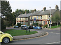
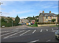
2

Tree house on Barkway Road, Royston
It's probably a shed but positioned in the same way.
Image: © David Howard
Taken: 30 Mar 2021
0.07 miles
5
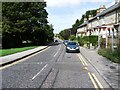
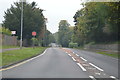
Barkway Street
The view back down the B1039 towards the town centre.
Image: © Mike W Hallett
Taken: 16 Aug 2009
0.10 miles
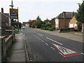
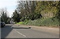
8
Shrubbery Grove, Royston
A turning off the A10 on the southern edge of town.
Image: © Keith Edkins
Taken: 27 Jul 2007
0.20 miles
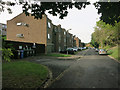
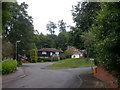
9
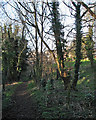
Nearing Royston on foot
The Hertfordshire Way path drops down from Flint Hall Farm to the edge of Royston, with woodland to the left.
Image: © John Sutton
Taken: 31 Dec 2015
0.20 miles