IMAGES TAKEN NEAR TO
Therfield, ROYSTON, SG8 9RB
Introduction
This page details the photographs taken nearby to SG8 9RB by members of the Geograph project.
The Geograph project started in 2005 with the aim of publishing, organising and preserving representative images for every square kilometre of Great Britain, Ireland and the Isle of Man.

There are currently over 7.5m images from over14,400 individuals and you can help contribute to the project by visiting https://www.geograph.org.uk
Image Map
Images are licensed for reuse under creativecommons.org/licenses/by-sa/2.0
Notes
- Clicking on the map will re-center to the selected point.
- The higher the marker number, the further away the image location is from the centre of the postcode.
Image Listing (6 Images Found)
Images are licensed for reuse under creativecommons.org/licenses/by-sa/2.0
Image
Details
Distance
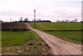
2
Driveway to Slate Hall Farm, near Buntingford
A driveway leading to Slate Hall Farm, in the north Hertfordshire countryside.
Image: © Malc McDonald
Taken: 25 Sep 2022
0.21 miles
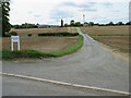
3
Chapel Green, near Buntingford
Chapel Green is a minor road through countryside in north Hertfordshire.
Image: © Malc McDonald
Taken: 25 Sep 2022
0.22 miles
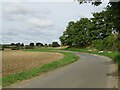
4
Sandon Road, near Buntingford
A view eastwards along Sandon Road, a minor road through north Hertfordshire countryside.
Image: © Malc McDonald
Taken: 25 Sep 2022
0.24 miles
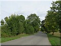
5
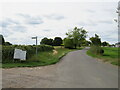
Sandon Road, near Buntingford
Sandon Road is a minor lane through north Hertfordshire countryside, leading to the village of Sandon. A public footpath leads off to the left, indicated by the signpost.
Image: © Malc McDonald
Taken: 25 Sep 2022
0.25 miles
6
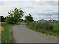
Sandon Road, near Buntingford
Sandon Road is a minor lane leading to the village of Sandon in north Hertfordshire. The buildings in the background are business units attached to a farm.
Image: © Malc McDonald
Taken: 25 Sep 2022
0.25 miles