IMAGES TAKEN NEAR TO
Garden Lane, ROYSTON, SG8 9EH
Introduction
This page details the photographs taken nearby to Garden Lane, SG8 9EH by members of the Geograph project.
The Geograph project started in 2005 with the aim of publishing, organising and preserving representative images for every square kilometre of Great Britain, Ireland and the Isle of Man.

There are currently over 7.5m images from over14,400 individuals and you can help contribute to the project by visiting https://www.geograph.org.uk
Image Map
Images are licensed for reuse under creativecommons.org/licenses/by-sa/2.0
Notes
- Clicking on the map will re-center to the selected point.
- The higher the marker number, the further away the image location is from the centre of the postcode.
Image Listing (107 Images Found)
Images are licensed for reuse under creativecommons.org/licenses/by-sa/2.0
Image
Details
Distance
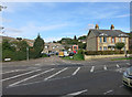
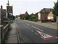
1
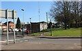
A10 London Road, Royston
Heading into the centre of town.
Image: © Robin Webster
Taken: 12 Feb 2018
0.07 miles
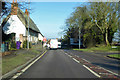
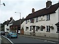
4
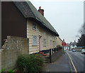
Thatched Cottages, Royston
These cottages situated on the A10, Ermine Street as it enters the town from the south once contained the Three Horseshoes public house.
Image: © John Partridge
Taken: 22 Mar 2007
0.09 miles
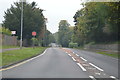
8
Closed public toilets on Market Hill, Royston
They have been closed for some years.
Image: © David Howard
Taken: 30 Mar 2021
0.11 miles
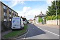
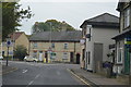
9
Pubs near Royston Market
At the turn of the 19th century there were nearly 50 public houses in Royston, now reduced to 9.
Image: © Jo Edkins
Taken: 24 Sep 2008
0.11 miles