IMAGES TAKEN NEAR TO
Sun Hill, ROYSTON, SG8 9AU
Introduction
This page details the photographs taken nearby to Sun Hill, SG8 9AU by members of the Geograph project.
The Geograph project started in 2005 with the aim of publishing, organising and preserving representative images for every square kilometre of Great Britain, Ireland and the Isle of Man.

There are currently over 7.5m images from over14,400 individuals and you can help contribute to the project by visiting https://www.geograph.org.uk
Image Map
Images are licensed for reuse under creativecommons.org/licenses/by-sa/2.0
Notes
- Clicking on the map will re-center to the selected point.
- The higher the marker number, the further away the image location is from the centre of the postcode.
Image Listing (158 Images Found)
Images are licensed for reuse under creativecommons.org/licenses/by-sa/2.0
Image
Details
Distance
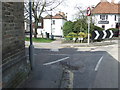
1
Upper King Street
Looking north, down the hill.
Image: © Jo Edkins
Taken: 24 Sep 2008
0.07 miles
2
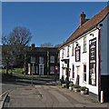
Royston: The Chequers
Next to The Old Bull Inn at the top of High Street.
Image: © John Sutton
Taken: 2 Feb 2016
0.07 miles
3
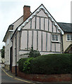
Timber-frame building in Upper King Street
This building has decorative plasterwork or pargetting on the front.
Image: © Jo Edkins
Taken: 24 Sep 2008
0.07 miles
4
Old Milepost
Old milepost between the wall and street sign on what was the A.10 at Royston, Hertfordshire for close up view see http://www.geograph.org.uk/photo/1790037
Image: © Keith Evans
Taken: 6 Apr 2010
0.07 miles
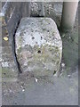
5
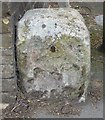
Old Milestone by the A10, London Road, Royston parish
Stone post (plate lost) by the A10, in parish of Royston (North Hertfordshire District), London Road, junction with Sun Hill, in pavement, on West side of road. Wadesmill plate, erected by the Wadesmill turnpike trust in the 19th century.
Inscription once read:-
(LONDON)
(38)
(BARKWAY)
(3)
(CAMBRIDGE)
(13)
(CAMBRIDGE)
({hand})
(AD MDCCCXXXII)
Hertfordshire HER & St Albans UAD.
HHER Number: 5048 https://www.heritagegateway.org.uk/Gateway/Results_Single.aspx?uid=MHT5048&resourceID=1008
Milestone Society National ID: HE_LK38
Image: © MW Hallett
Taken: 7 Sep 2001
0.07 miles
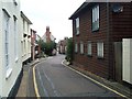
6
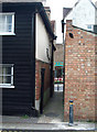
Alley between Upper King Street and High Street
Image: © Jo Edkins
Taken: 24 Sep 2008
0.08 miles
7
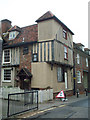
Timber framed house in Upper King Street
Timber framed houses with jettied floors can be seen throughout Royston. Such buildings date from Tudor times. This example has decorative plasterwork or pargetting.
Image: © Jo Edkins
Taken: 24 Sep 2008
0.08 miles
8
Old Milepost
Old milepost on what was the A.10 at Royston, Hertfordshire for overall view see http://www.geograph.org.uk/photo/1790019
Image: © Keith Evans
Taken: 6 Apr 2010
0.08 miles
9

'The Chequers' - High Street, Royston, Hertfordshire
Image: © Brian Chadwick
Taken: 14 Apr 2014
0.08 miles