IMAGES TAKEN NEAR TO
Nuthampstead, ROYSTON, SG8 8LR
Introduction
This page details the photographs taken nearby to SG8 8LR by members of the Geograph project.
The Geograph project started in 2005 with the aim of publishing, organising and preserving representative images for every square kilometre of Great Britain, Ireland and the Isle of Man.

There are currently over 7.5m images from over14,400 individuals and you can help contribute to the project by visiting https://www.geograph.org.uk
Image Map
Images are licensed for reuse under creativecommons.org/licenses/by-sa/2.0
Notes
- Clicking on the map will re-center to the selected point.
- The higher the marker number, the further away the image location is from the centre of the postcode.
Image Listing (10 Images Found)
Images are licensed for reuse under creativecommons.org/licenses/by-sa/2.0
Image
Details
Distance
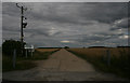
2
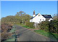
Morrice Green Cottage
This is the lane from Nuthampstead to Barley (ahead).
Image: © John Sutton
Taken: 17 Jan 2023
0.05 miles
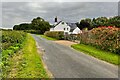
4
The start of a footpath at Morrice Green
This is the start of Public Footpath 1, to Bell Lane in Nuthampstead, half a mile away. It connects to a path to Barkway.
Image: © John Sutton
Taken: 17 Jan 2023
0.08 miles
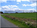
5
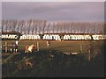
Nuthampstead Shooting Ground
Sited on the old runways of an American War Time airfield.
Image: © Nick Rout
Taken: 22 Jul 2007
0.10 miles
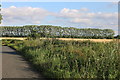
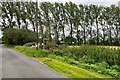
8

Leaving Nuthampstead
On the way to Barley.
Image: © Robin Webster
Taken: 17 Feb 2019
0.12 miles
9
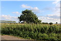
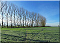
Horses and hay-bales
Farm scene near Nuthampstead
Image: © Steve F
Taken: 25 Nov 2006
0.12 miles