IMAGES TAKEN NEAR TO
Burrs Lane, ROYSTON, SG8 8EP
Introduction
This page details the photographs taken nearby to Burrs Lane, SG8 8EP by members of the Geograph project.
The Geograph project started in 2005 with the aim of publishing, organising and preserving representative images for every square kilometre of Great Britain, Ireland and the Isle of Man.

There are currently over 7.5m images from over14,400 individuals and you can help contribute to the project by visiting https://www.geograph.org.uk
Image Map
Images are licensed for reuse under creativecommons.org/licenses/by-sa/2.0
Notes
- Clicking on the map will re-center to the selected point.
- The higher the marker number, the further away the image location is from the centre of the postcode.
Image Listing (102 Images Found)
Images are licensed for reuse under creativecommons.org/licenses/by-sa/2.0
Image
Details
Distance
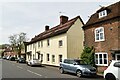
3
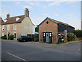
Former village bath house
Built in 1867.
the foundation stone has an inscription
"BATHS/Built by the Hon. Mrs. Vernon Harcourt/ 1867"
Image: © Jeff Tomlinson
Taken: 24 Mar 2008
0.05 miles
4
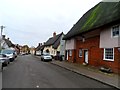
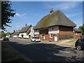
Thatched buildings in Barkway
See http://www.geograph.org.uk/photo/48971 for an almost identical photo from 2005. The thatch on the second house on the right was being done at that time.
Image: © Bikeboy
Taken: 2 Dec 2013
0.06 miles
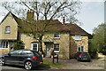
8
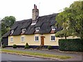
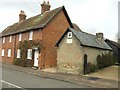
Thatched house, Barkway
Grade II listed dwelling, described at this https://historicengland.org.uk/listing/the-list/list-entry/1174920.
Image: © Jim Osley
Taken: 11 Aug 2016
0.07 miles