IMAGES TAKEN NEAR TO
Barkway, ROYSTON, SG8 8DA
Introduction
This page details the photographs taken nearby to SG8 8DA by members of the Geograph project.
The Geograph project started in 2005 with the aim of publishing, organising and preserving representative images for every square kilometre of Great Britain, Ireland and the Isle of Man.

There are currently over 7.5m images from over14,400 individuals and you can help contribute to the project by visiting https://www.geograph.org.uk
Image Map
Images are licensed for reuse under creativecommons.org/licenses/by-sa/2.0
Notes
- Clicking on the map will re-center to the selected point.
- The higher the marker number, the further away the image location is from the centre of the postcode.
Image Listing (7 Images Found)
Images are licensed for reuse under creativecommons.org/licenses/by-sa/2.0
Image
Details
Distance
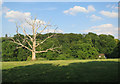
4
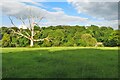
Dead oak by the footpath to Newsells
Hugh Venables was here 5 years ago Image and it is still standing, and still dead.
Image: © Philip Jeffrey
Taken: 24 Jun 2023
0.22 miles
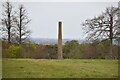
5
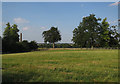
Field at Newsells Farm
With the top of the obelisk visible.
Image: © Hugh Venables
Taken: 6 Jul 2018
0.22 miles