IMAGES TAKEN NEAR TO
Heron Way, ROYSTON, SG8 7XH
Introduction
This page details the photographs taken nearby to Heron Way, SG8 7XH by members of the Geograph project.
The Geograph project started in 2005 with the aim of publishing, organising and preserving representative images for every square kilometre of Great Britain, Ireland and the Isle of Man.

There are currently over 7.5m images from over14,400 individuals and you can help contribute to the project by visiting https://www.geograph.org.uk
Image Map
Images are licensed for reuse under creativecommons.org/licenses/by-sa/2.0
Notes
- Clicking on the map will re-center to the selected point.
- The higher the marker number, the further away the image location is from the centre of the postcode.
Image Listing (22 Images Found)
Images are licensed for reuse under creativecommons.org/licenses/by-sa/2.0
Image
Details
Distance
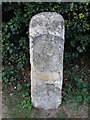
1
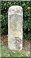
Old Milepost
Old milepost on what was the A.10 at Royston, Hertfordshire for close up view see http://www.geograph.org.uk/photo/1537186 and for more info on the stone see http://milestones.megalithia.com/sites/tl361418.htm do have a look at their home page.
Image: © Keith Evans
Taken: 12 Oct 2009
0.04 miles
2
Old Milepost
Old milepost on what was the A.10 at Royston, Hertfordshire for overall view see http://www.geograph.org.uk/photo/1537182 and for more info on the stone see http://milestones.megalithia.com/sites/tl361418.htm do have a look at their home page.
Image: © Keith Evans
Taken: 12 Oct 2009
0.05 miles
3
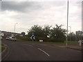
Old Milestone by the A10, Melbourn Road, Royston parish
Stone post (plate lost) by the A10, in parish of ROYSTON (NORTH HERTFORDSHIRE District), Melbourn Road, on the verge, on West side of road. Wadesmill plate, erected by the Wadesmill turnpike trust in the 19th century.
Inscription once read:-
(LONDON)
(39)
(BARKWAY)
(4)
(CAMBRIDGE)
(12)
(CAMBRIDGE)
({hand})
(A.D.)
(MDCCCXXXI)
Carved benchmark on front face.
Hertfordshire HER.
HHER Number: 11522 https://www.heritagegateway.org.uk/Gateway/Results_Single.aspx?uid=MHT11522&resourceID=1008
Milestone Society National ID: HE_LK39.
Image: © Robin Hall
Taken: Unknown
0.05 miles
8
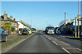
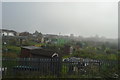
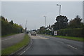
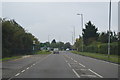
A10 Melbourn Road, Royston
Heading north out of town.
Image: © Robin Webster
Taken: 12 Feb 2018
0.12 miles