IMAGES TAKEN NEAR TO
High Street, ROYSTON, SG8 7SS
Introduction
This page details the photographs taken nearby to High Street, SG8 7SS by members of the Geograph project.
The Geograph project started in 2005 with the aim of publishing, organising and preserving representative images for every square kilometre of Great Britain, Ireland and the Isle of Man.

There are currently over 7.5m images from over14,400 individuals and you can help contribute to the project by visiting https://www.geograph.org.uk
Image Map
Images are licensed for reuse under creativecommons.org/licenses/by-sa/2.0
Notes
- Clicking on the map will re-center to the selected point.
- The higher the marker number, the further away the image location is from the centre of the postcode.
Image Listing (136 Images Found)
Images are licensed for reuse under creativecommons.org/licenses/by-sa/2.0
Image
Details
Distance
1
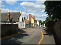
Fowlmere village centre
Of the three public houses in this photograph two are closed. In the foreground is the Queen's Head (closed), in the centre the Swan (recently reopened) and the white building on the left is the Chequers (recently closed).
Image: © David Beresford
Taken: 11 Aug 2013
0.01 miles
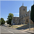
2
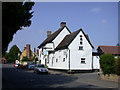
The Chequers, Fowlmere
Late C15 or early C16 with C17 additions. Inscription below jetty 'ANO DOM 1675 WT'. Timber-framed and plastered with tarred brick plinth, C20 plain tiled roofs. Samuel Pepys stayed at the inn in 1660. Grade II listed. http://www.heritagegateway.org.uk/Gateway/Results_Single.aspx?resourceID=5&uid=52938
Pepys wrote "Then up again and as far as Foulmer, within six miles of Cambridge, my mare being almost tired: here we lay at the Chequer, playing at cards till supper, which was a breast of veal roasted." (24 February 1659/60)
Image: © Keith Edkins
Taken: 14 May 2008
0.03 miles
4
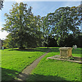
In Fowlmere churchyard
Looking south-west at eleven o'clock on a bright and blowy October morning.
Image: © John Sutton
Taken: 22 Oct 2021
0.04 miles

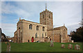
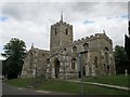
7
Fowlmere High Street and St Mary's
This is the road to Cambridge. Like a number of South Cambridgeshire churches, St Mary's has a tower topped by a flèche (or Hertfordshire spike as it is known in these parts). For another view of this interesting church, see Image
Image: © John Sutton
Taken: 9 Aug 2022
0.04 miles
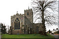
9
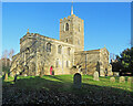
Fowlmere: St Mary - from the west
"A sizeable [Grade I listed] cruciform church of flint and pebble rubble, much restored in 1869" (Nikolaus Pevsner). Unusually there is no south aisle. Towers with lead-covered spikes are quite common in this part of Cambridgeshire, close to Hertfordshire, where there are many. Nearby Thriplow has a similar feature. This picture was taken on a bright and blowy October morning.
Image: © John Sutton
Taken: 22 Oct 2021
0.04 miles
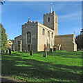
10
Fowlmere: blue sky and St Mary's
Bright sunlight and deep shadows on the morning of Boxing Day. "A sizeable [Grade I listed] cruciform church of flint and pebble rubble, much restored in 1869" (Nikolaus Pevsner). Unusually there is no south aisle. Towers with lead-covered spikes are quite common in this part of Cambridgeshire, close to Hertfordshire, where there are many.
Image: © John Sutton
Taken: 26 Dec 2022
0.04 miles