IMAGES TAKEN NEAR TO
Melrose, ROYSTON, SG8 6NY
Introduction
This page details the photographs taken nearby to Melrose, SG8 6NY by members of the Geograph project.
The Geograph project started in 2005 with the aim of publishing, organising and preserving representative images for every square kilometre of Great Britain, Ireland and the Isle of Man.

There are currently over 7.5m images from over14,400 individuals and you can help contribute to the project by visiting https://www.geograph.org.uk
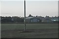
Image Map
Images are licensed for reuse under creativecommons.org/licenses/by-sa/2.0
Notes
- Clicking on the map will re-center to the selected point.
- The higher the marker number, the further away the image location is from the centre of the postcode.
Image Listing (37 Images Found)
Images are licensed for reuse under creativecommons.org/licenses/by-sa/2.0
Image
Details
Distance
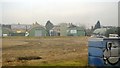
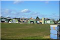
8
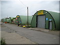
Meldreth: Nissen huts
There are six of these remarkably well maintained large nissen huts in a small industrial estate off Station Road. They certainly date from the Second World War as they are shown as a block of six on the Ordnance Survey's map of 1950. Directly behind them used to run the tramway to the Meldreth Brick Works.
Image: © Nigel Cox
Taken: 6 Jul 2008
0.07 miles
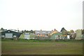
10
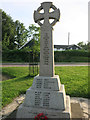
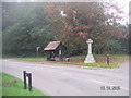
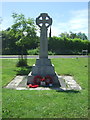
Meldreth War Memorial
The names of those lost in WWI. See Image for a wider view of the memorial.
Image: © Hugh Venables
Taken: 17 Jul 2014
0.08 miles