IMAGES TAKEN NEAR TO
Mortlock Close, ROYSTON, SG8 6DA
Introduction
This page details the photographs taken nearby to Mortlock Close, SG8 6DA by members of the Geograph project.
The Geograph project started in 2005 with the aim of publishing, organising and preserving representative images for every square kilometre of Great Britain, Ireland and the Isle of Man.

There are currently over 7.5m images from over14,400 individuals and you can help contribute to the project by visiting https://www.geograph.org.uk
Image Map
Images are licensed for reuse under creativecommons.org/licenses/by-sa/2.0
Notes
- Clicking on the map will re-center to the selected point.
- The higher the marker number, the further away the image location is from the centre of the postcode.
Image Listing (94 Images Found)
Images are licensed for reuse under creativecommons.org/licenses/by-sa/2.0
Image
Details
Distance
2
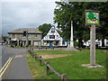
Melbourn: Village sign and War Memorial
The village sign reflects the history and strength of religious dissention in the area.
Image: © Nigel Cox
Taken: 6 Jul 2008
0.05 miles
3
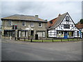
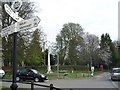
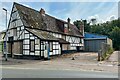
Melbourn crossroads
The crossroads marks the junction of the High Street, Mortlock Street, Station Road and Cambridge Road. Prior to the building of the bypass the A10 road used to follow the High Street and Cambridge Road. On view is a 2000 Millennium direction finger post showing London 40 miles, Royston 2½; Newmarket 24, Barley 4¾; Cambridge 10, Foxton 2¾; and Whaddon 1¾, Meldreth & Railway Station ¾. There is also a Best Kept Village sign from 1991. On the very far left there is a black sign attached to the side of the brick building showing the way to the Baptist Church, and on the very far right an ancient petrol pump next to the half-timbered garage can be seen.
Image: © Nigel Cox
Taken: 6 Jul 2008
0.06 miles
5
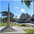
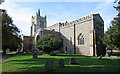
Melbourn War Memorial
The War Memorial stands next to the parish church at the crossroads in the centre of the village. The scaffolded house on the other side of the road is Grade II listed and was built about 1840. The listing explains that its walls are of clay bat and that it was during part of the 19th century The Elm Tree public house.
Image: © John Sutton
Taken: 13 Jun 2020
0.06 miles
6
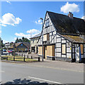
Melbourn: at the crossroads
During the coronavirus pandemic crisis the Co-op had a steady stream of customers on this bright Saturday morning, but South Cambs Motors was boarded up and permanently closed.
Image: © John Sutton
Taken: 13 Jun 2020
0.06 miles
7
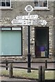
Old Direction Sign - Signpost by High Street, Melbourn
Annulus finial - 4 arms; Cambs modern halo by the UC road, in parish of Melbourn (South Cambridgeshire District), junction of High Street with Station Road, on grass triangle.
Surveyed
Milestone Society National ID: CA_TL3844
Image: © Milestone Society
Taken: Unknown
0.07 miles
8
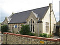
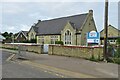
Melbourn County Primary School
The School is on the east side of Mortlock Street.
Image: © Nigel Cox
Taken: 6 Jul 2008
0.07 miles
9
Former garage site up for redevelopment
Image: © Philip Jeffrey
Taken: 16 Jul 2023
0.08 miles