IMAGES TAKEN NEAR TO
Bridge Street, ROYSTON, SG8 5SP
Introduction
This page details the photographs taken nearby to Bridge Street, SG8 5SP by members of the Geograph project.
The Geograph project started in 2005 with the aim of publishing, organising and preserving representative images for every square kilometre of Great Britain, Ireland and the Isle of Man.

There are currently over 7.5m images from over14,400 individuals and you can help contribute to the project by visiting https://www.geograph.org.uk
Image Map
Images are licensed for reuse under creativecommons.org/licenses/by-sa/2.0
Notes
- Clicking on the map will re-center to the selected point.
- The higher the marker number, the further away the image location is from the centre of the postcode.
Image Listing (9 Images Found)
Images are licensed for reuse under creativecommons.org/licenses/by-sa/2.0
Image
Details
Distance
1
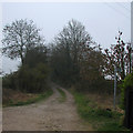
Paths south of Dyer's Green
The fingerpost points along a path to Kneesworth. The track straight ahead leads to the Meldreth-Kneesworth road.
Image: © John Sutton
Taken: 13 Mar 2014
0.04 miles
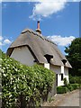
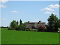
2
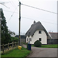
Dyer's Green: cottage in Bridge Street
The cottage is Grade II listed: see http://www.britishlistedbuildings.co.uk/en-52646-avondale-whaddon-cambridgeshire .
Image: © John Sutton
Taken: 13 Mar 2014
0.05 miles
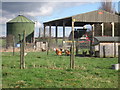
5
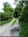
Byway 22
This leafy byway is mostly used by walkers but it is open to all traffic.
For those with a 4-wheel drive vehicle it is a short cut from Dyer's Green to Kneesworth
Image: © Mike W Hallett
Taken: 9 Aug 2009
0.09 miles

9
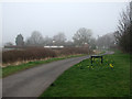
The edge of Dyer's Green
The sign among the daffodils marks the northern edge of the hamlet of Dyer's Green. The houses ahead are the southernmost in the straggling village of Whaddon.
Image: © John Sutton
Taken: 13 Mar 2014
0.15 miles