IMAGES TAKEN NEAR TO
Knutsford Road, ROYSTON, SG8 5HS
Introduction
This page details the photographs taken nearby to Knutsford Road, SG8 5HS by members of the Geograph project.
The Geograph project started in 2005 with the aim of publishing, organising and preserving representative images for every square kilometre of Great Britain, Ireland and the Isle of Man.

There are currently over 7.5m images from over14,400 individuals and you can help contribute to the project by visiting https://www.geograph.org.uk
Image Map
Images are licensed for reuse under creativecommons.org/licenses/by-sa/2.0
Notes
- Clicking on the map will re-center to the selected point.
- The higher the marker number, the further away the image location is from the centre of the postcode.
Image Listing (43 Images Found)
Images are licensed for reuse under creativecommons.org/licenses/by-sa/2.0
Image
Details
Distance
2
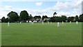
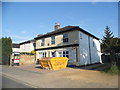
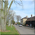
Willmott Recreation Ground and Pavilion
The Recreation Ground in South End was donated to Bassingbourn by Samuel Willmott
Image: © Mike W Hallett
Taken: 18 Jul 2009
0.09 miles
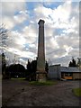
3
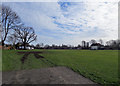
Bassingbourn: Willmott's Recreation Ground
The Recreation Ground was given to the Parish Council by Samuel Willmott in 1936.
Image: © John Sutton
Taken: 9 Mar 2018
0.10 miles
8
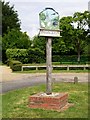
Bassingbourn village sign
The sign depicts the connection of the village with the airfield (now Bassingbourn Barracks), with pig farming and with the manufacture of the first London taxis.
Image: © Mike W Hallett
Taken: 8 Jun 2009
0.15 miles
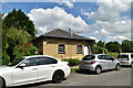
10
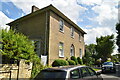
Bassingbourn: historic houses on South End
South End House’s brick façade of c 1810 conceals a 17th-century timber-framed farmhouse. The weatherboarded buildings are also Grade II listed (see https://www.britishlistedbuildings.co.uk/101309186-barns-coach-house-bakehouse-and-maltings-circa-5-metres-south-of-number-29-south-end-house-bassingbourn-cum-kneesworth#.WqK2-CiT7Za ).
Image: © John Sutton
Taken: 9 Mar 2018
0.15 miles