IMAGES TAKEN NEAR TO
Northfield Road, BALDOCK, SG7 5JQ
Introduction
This page details the photographs taken nearby to Northfield Road, SG7 5JQ by members of the Geograph project.
The Geograph project started in 2005 with the aim of publishing, organising and preserving representative images for every square kilometre of Great Britain, Ireland and the Isle of Man.

There are currently over 7.5m images from over14,400 individuals and you can help contribute to the project by visiting https://www.geograph.org.uk
Image Map
Images are licensed for reuse under creativecommons.org/licenses/by-sa/2.0
Notes
- Clicking on the map will re-center to the selected point.
- The higher the marker number, the further away the image location is from the centre of the postcode.
Image Listing (8 Images Found)
Images are licensed for reuse under creativecommons.org/licenses/by-sa/2.0
Image
Details
Distance
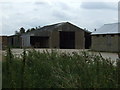
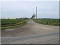
1
Kirby's Manor Farm
Northfield Road links Ashwell to Eyeworth (ahead).
Image: © John Sutton
Taken: 21 Mar 2017
0.01 miles
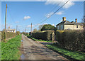
5
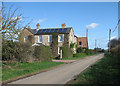
Popes Farm, Northfield Road
In the most northerly part of Hertfordshire, between Ashwell and Eyeworth (ahead).
Image: © John Sutton
Taken: 21 Mar 2017
0.14 miles
6
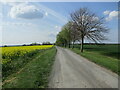
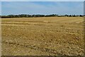
Wheatfield alongside Northfield Road
Image: © Jonathan Thacker
Taken: 30 Apr 2022
0.15 miles
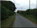
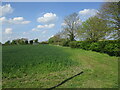
7
Entrance to driveway to Dunton Lodge Farm
Image: © Jeff Tomlinson
Taken: 22 Apr 2007
0.24 miles