IMAGES TAKEN NEAR TO
Hinxworth, BALDOCK, SG7 5EZ
Introduction
This page details the photographs taken nearby to SG7 5EZ by members of the Geograph project.
The Geograph project started in 2005 with the aim of publishing, organising and preserving representative images for every square kilometre of Great Britain, Ireland and the Isle of Man.

There are currently over 7.5m images from over14,400 individuals and you can help contribute to the project by visiting https://www.geograph.org.uk
Image Map
Images are licensed for reuse under creativecommons.org/licenses/by-sa/2.0
Notes
- Clicking on the map will re-center to the selected point.
- The higher the marker number, the further away the image location is from the centre of the postcode.
Image Listing (3 Images Found)
Images are licensed for reuse under creativecommons.org/licenses/by-sa/2.0
Image
Details
Distance
1
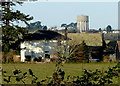
Saltmore Farm
Toplers Hill water tower in distance.
Image: © Dylan Mills
Taken: 6 Dec 2008
0.06 miles
2
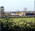
Saltmore Farm
Barns converted for small businesses
Image: © Dylan Mills
Taken: 6 Dec 2008
0.06 miles
3
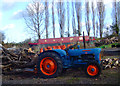
Fordson Dexta Tractor
In regular use at Capmore Farm Hinxworth.
Canal boat under construction in the background.
Image: © Dylan Mills
Taken: 6 Jan 2005
0.22 miles