IMAGES TAKEN NEAR TO
Trinity Road, HITCHIN, SG5 4EQ
Introduction
This page details the photographs taken nearby to Trinity Road, SG5 4EQ by members of the Geograph project.
The Geograph project started in 2005 with the aim of publishing, organising and preserving representative images for every square kilometre of Great Britain, Ireland and the Isle of Man.

There are currently over 7.5m images from over14,400 individuals and you can help contribute to the project by visiting https://www.geograph.org.uk
Image Map
Images are licensed for reuse under creativecommons.org/licenses/by-sa/2.0
Notes
- Clicking on the map will re-center to the selected point.
- The higher the marker number, the further away the image location is from the centre of the postcode.
Image Listing (18 Images Found)
Images are licensed for reuse under creativecommons.org/licenses/by-sa/2.0
Image
Details
Distance
1

Flats on Regent Street
A nod to village chapel architecture, maybe?
Image: © David Martin
Taken: 29 May 2022
0.10 miles


8
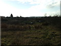
Allotments in Stotfold.
These allotments look like they could do with a bit of care and attention.
Image: © Robin Hall
Taken: 25 Dec 2005
0.13 miles
9

Funfair vehicles, Stotfold Green
It looks as if they are about to set up.
Image: © Robin Webster
Taken: 6 Sep 2015
0.17 miles