IMAGES TAKEN NEAR TO
Baldock Road, HITCHIN, SG5 4BN
Introduction
This page details the photographs taken nearby to Baldock Road, SG5 4BN by members of the Geograph project.
The Geograph project started in 2005 with the aim of publishing, organising and preserving representative images for every square kilometre of Great Britain, Ireland and the Isle of Man.

There are currently over 7.5m images from over14,400 individuals and you can help contribute to the project by visiting https://www.geograph.org.uk
Image Map (Loading...)


Getting Data...Please wait
Leaflet Map data © OpenStreetMap
Images are licensed for reuse under creativecommons.org/licenses/by-sa/2.0
Notes
- Clicking on the map will re-center to the selected point.
- The higher the marker number, the further away the image location is from the centre of the postcode.
Image Listing (5 Images Found)
Images are licensed for reuse under creativecommons.org/licenses/by-sa/2.0
Image
Details
Distance
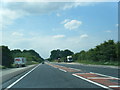
2
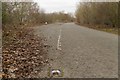
Part of the old A507 near Boundary Farm
Image: © Mark Anderson
Taken: 3 Jan 2019
0.10 miles
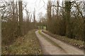
4
Stotfold Mill, Mill Lane
This watermill has been fully restored to working condition following a fire which almost destroyed the building in 1992. It has the UK's widest cornmill waterwheel and is a magnificent site to see.
Image: © Paul Redwood
Taken: Unknown
0.22 miles
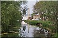
5

Mill House.
This photo taken from pretty much the same spot as Paul Dixon's of the mill pond in Image However, this is the house at the other end of the pond which today was frozen.
Image: © Robin Hall
Taken: 29 Jan 2006
0.22 miles