IMAGES TAKEN NEAR TO
High Street, HITCHIN, SG4 8UD
Introduction
This page details the photographs taken nearby to High Street, SG4 8UD by members of the Geograph project.
The Geograph project started in 2005 with the aim of publishing, organising and preserving representative images for every square kilometre of Great Britain, Ireland and the Isle of Man.

There are currently over 7.5m images from over14,400 individuals and you can help contribute to the project by visiting https://www.geograph.org.uk
Image Map
Images are licensed for reuse under creativecommons.org/licenses/by-sa/2.0
Notes
- Clicking on the map will re-center to the selected point.
- The higher the marker number, the further away the image location is from the centre of the postcode.
Image Listing (20 Images Found)
Images are licensed for reuse under creativecommons.org/licenses/by-sa/2.0
Image
Details
Distance

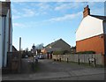
2
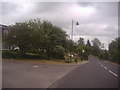
High Street Codicote at the junction of New Town
Image: © David Howard
Taken: 31 May 2012
0.02 miles

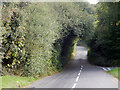
4
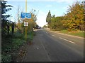
Codicote: B656 Codicote Road
Approaching the southern outskirts of Codicote this is the B656, once the A600 between Welwyn and Hitchin.
Image: © Nigel Cox
Taken: 22 Nov 2015
0.03 miles
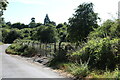
6
Grass triangle, Codicote
This is at the junction of Rabley Heath Road with the B656.
Image: © Humphrey Bolton
Taken: 4 Feb 2020
0.07 miles
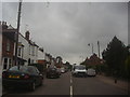
7
Codicote: The Opening
This intriguingly named road is off the High Street. It is a short private road but a public Restricted Byway that leads to Cowards Lane. Looking at old Ordnance Survey maps available on line the whole area on this side of the High Street is shown as allotment gardens in the 1881 edition, but the route, and some of the current houses along the High Street, were in place by 1898.
Image: © Nigel Cox
Taken: 22 Nov 2015
0.08 miles
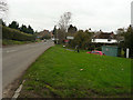
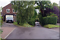
8
Rabley Heath Road, Codicote
Rabley Heath Road leads down from its junction with the B656 on the edge of Codicote towards Rableyheath.
Image: © Stephen McKay
Taken: 12 Oct 2021
0.09 miles
10
Cowards Lane, Codicote
A village back road connecting St Albans Road with the bottom of High Street.
Image: © Stephen McKay
Taken: 26 Sep 2023
0.10 miles