IMAGES TAKEN NEAR TO
Hitchin Road, HITCHIN, SG4 8TG
Introduction
This page details the photographs taken nearby to Hitchin Road, SG4 8TG by members of the Geograph project.
The Geograph project started in 2005 with the aim of publishing, organising and preserving representative images for every square kilometre of Great Britain, Ireland and the Isle of Man.

There are currently over 7.5m images from over14,400 individuals and you can help contribute to the project by visiting https://www.geograph.org.uk
Image Map
Images are licensed for reuse under creativecommons.org/licenses/by-sa/2.0
Notes
- Clicking on the map will re-center to the selected point.
- The higher the marker number, the further away the image location is from the centre of the postcode.
Image Listing (9 Images Found)
Images are licensed for reuse under creativecommons.org/licenses/by-sa/2.0
Image
Details
Distance
2
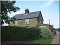
Cottage on access road to Burleigh Farm
The design tells me that it was built as cheaply as possible. For the farm worker I guess.
Image: © Jack Hill
Taken: 31 Aug 2005
0.03 miles
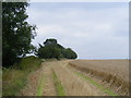
3
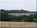
Fields by London Road near Old Knebworth
Image: © David Howard
Taken: 31 May 2012
0.08 miles
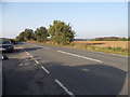
5
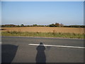
Shadow across the B656, Knebworth
Clearly looking east by the sundial
Image: © David Howard
Taken: 15 Oct 2017
0.10 miles
7
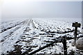
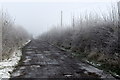
Private farm track to Graffidge Wood
Image: © Philip Jeffrey
Taken: 16 Jan 2013
0.14 miles
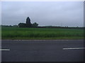
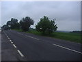
8
View parallel to the B656 southwards towards Graffridge
Image: © David Sands
Taken: 30 Aug 2007
0.16 miles
9
View from B656 north-west across fields towards Easthall
Image: © David Sands
Taken: 30 Aug 2007
0.20 miles