IMAGES TAKEN NEAR TO
St. Marys Rise, HITCHIN, SG4 8PN
Introduction
This page details the photographs taken nearby to St. Marys Rise, SG4 8PN by members of the Geograph project.
The Geograph project started in 2005 with the aim of publishing, organising and preserving representative images for every square kilometre of Great Britain, Ireland and the Isle of Man.

There are currently over 7.5m images from over14,400 individuals and you can help contribute to the project by visiting https://www.geograph.org.uk
Image Map (Loading...)


Getting Data...Please wait
Leaflet Map data © OpenStreetMap
Images are licensed for reuse under creativecommons.org/licenses/by-sa/2.0
Notes
- Clicking on the map will re-center to the selected point.
- The higher the marker number, the further away the image location is from the centre of the postcode.
Image Listing (19 Images Found)
Images are licensed for reuse under creativecommons.org/licenses/by-sa/2.0
Image
Details
Distance
1
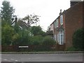
Houses in Colemans Road Breachwood Green
These houses date from turn of the 19th century
Image: © Jack Hill
Taken: 31 Aug 2005
0.10 miles
2
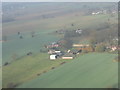
Colemans at Breachwood Green
Seen on approach to Luton Airport, about 2km from touchdown on Runway 26.
Image: © M J Richardson
Taken: 24 Nov 2011
0.12 miles
3
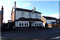
The Red Lion Public House, Breachwood Green
On Chapel Road at the junction with Oxford Road
http://redlionbreachwoodgreen.co.uk/index.html
Image: © Geographer
Taken: 7 Mar 2018
0.14 miles
4
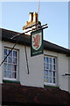
The Red Lion Public House sign
On Chapel Road at the junction with Oxford Road
http://redlionbreachwoodgreen.co.uk/index.html
Image: © Geographer
Taken: 7 Mar 2018
0.14 miles
5
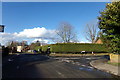
Chapel Road, Breachwood Green
At the junction with Oxford Road near the Red Lion Public House
Image: © Geographer
Taken: 7 Mar 2018
0.14 miles
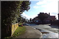
6
Oxford Road, Breachwood Green
At the junction with Chapel Road near The Red Lion Public House
Image: © Geographer
Taken: 7 Mar 2018
0.14 miles
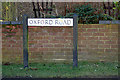
7
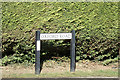
Oxford Road sign
On Oxford Road at the junction with Chapel Road near The Red Lion Public House
Image: © Geographer
Taken: 7 Mar 2018
0.14 miles
8
Chapel Road, Breachwood Green
At the junction with Oxford Road near The Red Lion Public House
Image: © Geographer
Taken: 7 Mar 2018
0.14 miles
9
Oxford Road sign
On Oxford Road at the junction with Chapel Road near The Red Lion Public House
Image: © Geographer
Taken: 7 Mar 2018
0.15 miles
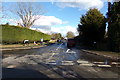
10
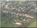
Breachwood Green
Oxford Road, connecting Chapel and Lower Roads. Seen on approach to Runway 26 at Luton airport.
Image: © M J Richardson
Taken: 24 Nov 2011
0.18 miles