IMAGES TAKEN NEAR TO
Whitehall Lane, HITCHIN, SG4 8JZ
Introduction
This page details the photographs taken nearby to Whitehall Lane, SG4 8JZ by members of the Geograph project.
The Geograph project started in 2005 with the aim of publishing, organising and preserving representative images for every square kilometre of Great Britain, Ireland and the Isle of Man.

There are currently over 7.5m images from over14,400 individuals and you can help contribute to the project by visiting https://www.geograph.org.uk
Image Map
Images are licensed for reuse under creativecommons.org/licenses/by-sa/2.0
Notes
- Clicking on the map will re-center to the selected point.
- The higher the marker number, the further away the image location is from the centre of the postcode.
Image Listing (5 Images Found)
Images are licensed for reuse under creativecommons.org/licenses/by-sa/2.0
Image
Details
Distance
1
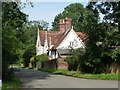
Whitehall Farmhouse
A grade II listed building originating in the 16th century.
Image: © Robin Webster
Taken: 6 Sep 2015
0.06 miles
2
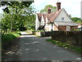
Whitehall Farmhouse. King's Walden
This is a 16C hall-house, with the gables wing furthest away added in the mid- 19C Beyond that there is a dovecote, which I did not see. The buildings are listed, Grade II.
Image: © Humphrey Bolton
Taken: 22 Jun 2019
0.07 miles
4

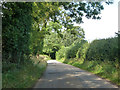
Path towards Whitehall Farm
Looking west from where the path crosses the road at TL175236, the path crosses a field toward Whitehall Farm - just out of shot over the crest of the hill.
Image: © Rob Hinkley
Taken: 18 Jun 2006
0.21 miles
5
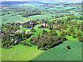
King's Walden from the air
St Mary's Church is to the left of Kingswalden Bury, at the centre of the photo which was taken from a Luton bound flight from Prague.
Image: © Thomas Nugent
Taken: 11 May 2012
0.24 miles