IMAGES TAKEN NEAR TO
Bendish, HITCHIN, SG4 8JE
Introduction
This page details the photographs taken nearby to SG4 8JE by members of the Geograph project.
The Geograph project started in 2005 with the aim of publishing, organising and preserving representative images for every square kilometre of Great Britain, Ireland and the Isle of Man.

There are currently over 7.5m images from over14,400 individuals and you can help contribute to the project by visiting https://www.geograph.org.uk
Image Map (Loading...)


Getting Data...Please wait
Leaflet Map data © OpenStreetMap
Images are licensed for reuse under creativecommons.org/licenses/by-sa/2.0
Notes
- Clicking on the map will re-center to the selected point.
- The higher the marker number, the further away the image location is from the centre of the postcode.
Image Listing (8 Images Found)
Images are licensed for reuse under creativecommons.org/licenses/by-sa/2.0
Image
Details
Distance
1
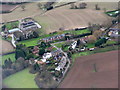
Bendish and Pickering's Farm
Looking southeast about 3km from touchdown at Luton Airport.
Image: © M J Richardson
Taken: 12 Dec 2014
0.11 miles
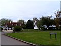
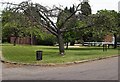
4
Part of the village green, Bendish, St Paul's Walden
Image: © Humphrey Bolton
Taken: 22 Jun 2019
0.17 miles
5
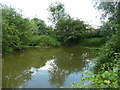
Village pond, Bendish, St Paul's Walden
Rather a gloomy, murky pond, and not accessible.
Image: © Humphrey Bolton
Taken: 22 Jun 2019
0.18 miles
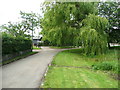
6
Village Green and Sign at Bendish
The village Green in the hamlet of Bendish. The wooden sign to the right of the shot shows the name of Bendish.
Image: © Richard Thomas
Taken: 13 Jun 2006
0.19 miles
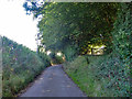
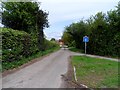
8
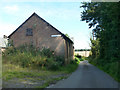
Barn at Law Hall Farm
The lane is descending to Lilley Bottom.
Image: © Robin Webster
Taken: 6 Sep 2015
0.25 miles