IMAGES TAKEN NEAR TO
Skegsbury Lane, HITCHIN, SG4 8EX
Introduction
This page details the photographs taken nearby to Skegsbury Lane, SG4 8EX by members of the Geograph project.
The Geograph project started in 2005 with the aim of publishing, organising and preserving representative images for every square kilometre of Great Britain, Ireland and the Isle of Man.

There are currently over 7.5m images from over14,400 individuals and you can help contribute to the project by visiting https://www.geograph.org.uk
Image Map
Images are licensed for reuse under creativecommons.org/licenses/by-sa/2.0
Notes
- Clicking on the map will re-center to the selected point.
- The higher the marker number, the further away the image location is from the centre of the postcode.
Image Listing (8 Images Found)
Images are licensed for reuse under creativecommons.org/licenses/by-sa/2.0
Image
Details
Distance
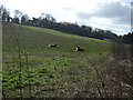
3
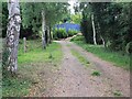
Driveway off Kimpton Bottom
Driveway to building marked on map as stables.
Image: © David P Howard
Taken: 29 Jul 2011
0.13 miles
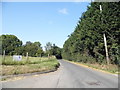
4
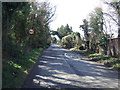
Kimpton Bottom
Heading south west towards Harpenden.
Image: © JThomas
Taken: 22 Feb 2014
0.13 miles
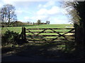
5
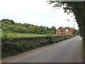
Cottage Farm, Kimpton Bottom
View WSW along Kimpton Bottom towards a house which appears to be undergoing extensive renovation works.
Image: © David P Howard
Taken: 29 Jul 2011
0.15 miles
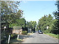
7
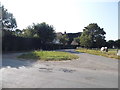
Ash Drive at the junction of Kimpton Bottom
Image: © David Howard
Taken: 22 Jul 2014
0.25 miles