IMAGES TAKEN NEAR TO
Dalton Way, HITCHIN, SG4 8BG
Introduction
This page details the photographs taken nearby to Dalton Way, SG4 8BG by members of the Geograph project.
The Geograph project started in 2005 with the aim of publishing, organising and preserving representative images for every square kilometre of Great Britain, Ireland and the Isle of Man.

There are currently over 7.5m images from over14,400 individuals and you can help contribute to the project by visiting https://www.geograph.org.uk
Image Map (Loading...)


Getting Data...Please wait
Leaflet Map data © OpenStreetMap
Images are licensed for reuse under creativecommons.org/licenses/by-sa/2.0
Notes
- Clicking on the map will re-center to the selected point.
- The higher the marker number, the further away the image location is from the centre of the postcode.
Image Listing (28 Images Found)
Images are licensed for reuse under creativecommons.org/licenses/by-sa/2.0
Image
Details
Distance
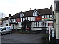
1
The Bull Inn Whitwell
Looks to be a successful pub
Image: © Jack Hill
Taken: 28 Aug 2005
0.04 miles
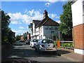
2
The Maiden's Head pub, Whitwell
On the High Street.
Image: © JThomas
Taken: 22 Feb 2014
0.04 miles
3
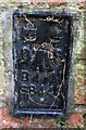
OS Flush Bracket S8440 Whitwell, former Baptist Church
OS Flush Bracket S8440 Whitwell, former Baptist Church, now flats
Image: © thejackrustles
Taken: 18 Oct 2019
0.05 miles
4
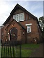
Former Baptist Church, Whitwell
OS Flush Bracket S8440 on right hand side next to wheelie bin
Image: © thejackrustles
Taken: 18 Oct 2019
0.05 miles
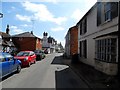
7
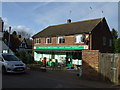
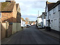
Whitwell Post Office and stores
On the High Street.
Image: © JThomas
Taken: 22 Feb 2014
0.06 miles
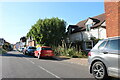
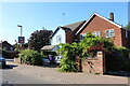
8
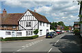
High Street, Whitwell, St Paul's Walden
The house is listed, Grade II. It was built as an open hall-house c.1500.
Image: © Humphrey Bolton
Taken: 22 Jun 2019
0.07 miles