IMAGES TAKEN NEAR TO
Chequers Lane, HITCHIN, SG4 7TT
Introduction
This page details the photographs taken nearby to Chequers Lane, SG4 7TT by members of the Geograph project.
The Geograph project started in 2005 with the aim of publishing, organising and preserving representative images for every square kilometre of Great Britain, Ireland and the Isle of Man.

There are currently over 7.5m images from over14,400 individuals and you can help contribute to the project by visiting https://www.geograph.org.uk
Image Map (Loading...)


Getting Data...Please wait
Leaflet Map data © OpenStreetMap
Images are licensed for reuse under creativecommons.org/licenses/by-sa/2.0
Notes
- Clicking on the map will re-center to the selected point.
- The higher the marker number, the further away the image location is from the centre of the postcode.
Image Listing (48 Images Found)
Images are licensed for reuse under creativecommons.org/licenses/by-sa/2.0
Image
Details
Distance
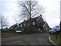
1
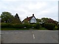
House where Chequer's Lane becomes Butcher's Lane
Image: © Bikeboy
Taken: 12 May 2013
0.08 miles
3
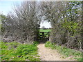
Gate on the public footpath around the western side of Wain Wood, Preston
Image: © Humphrey Bolton
Taken: 15 Apr 2015
0.12 miles
4
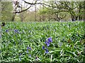
Wain Wood, Preston, Hertfordshire
This wood is carpeted with bluebells every April
Image: © Paul Dixon
Taken: 16 Apr 2005
0.12 miles
6
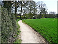
Footpath to Wain Wood, Preston
This view is looking back towards the start of the path at Chequers Lane.
Image: © Humphrey Bolton
Taken: 15 Apr 2015
0.13 miles
7
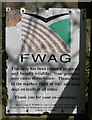
Notice at entrance to Wain Wood
Wain Wood is a surviving part of a large area of ancient woodland, and is a Site of Special Scientific Interest. There are some paths in the wood other than the public one, no doubt used by the local people, but they only affect a small part of the woodland.
Image: © Humphrey Bolton
Taken: 15 Apr 2015
0.15 miles
8

Footpath to Wain Wood
The path enters the wood at the centre of the image, and a branch path continues around the edge of the wood and continues northwards to Tatmorehills Lane, which is a track going all the way to Hitchin. These to paths are shown going across the field on the OS map, but they have been diverted around the edge.
Image: © Humphrey Bolton
Taken: 15 Apr 2015
0.15 miles
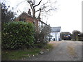
9

Chequers Lane, Preston
These look like former council houses.
Image: © Humphrey Bolton
Taken: 15 Apr 2015
0.16 miles
10
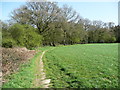
Public footpath around the western side of Wain Wood, Preston
The map shows the path following a straight line across the curve of the boundary of the wood, but it has been sensibly diverted around the edge to avoid damaging crops.
Image: © Humphrey Bolton
Taken: 15 Apr 2015
0.17 miles