IMAGES TAKEN NEAR TO
The Crescent, HITCHIN, SG4 7RE
Introduction
This page details the photographs taken nearby to The Crescent, SG4 7RE by members of the Geograph project.
The Geograph project started in 2005 with the aim of publishing, organising and preserving representative images for every square kilometre of Great Britain, Ireland and the Isle of Man.

There are currently over 7.5m images from over14,400 individuals and you can help contribute to the project by visiting https://www.geograph.org.uk
Image Map (Loading...)


Getting Data...Please wait
Leaflet Map data © OpenStreetMap
Images are licensed for reuse under creativecommons.org/licenses/by-sa/2.0
Notes
- Clicking on the map will re-center to the selected point.
- The higher the marker number, the further away the image location is from the centre of the postcode.
Image Listing (9 Images Found)
Images are licensed for reuse under creativecommons.org/licenses/by-sa/2.0
Image
Details
Distance
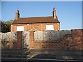
2
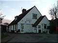
St Ippollyts post office.
That is not a spelling mistake. St Ippollyts has several different spellings. The sign on the post office spells it this way.
Image: © Robin Hall
Taken: 29 Nov 2005
0.06 miles
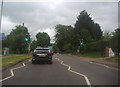
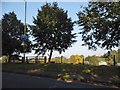
4
Brookend Lane at the junction of London Road
Image: © David Howard
Taken: 16 Jan 2022
0.08 miles
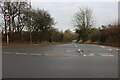
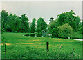
7
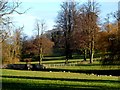
Parkland and ornamental bridge near St Ippollyts
Image: © Bikeboy
Taken: 22 Dec 2013
0.22 miles
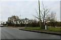
8
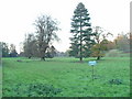
Parkland just outside Hitchin..
I've been driving past here for years and think that it would be a great place to build a house. This would be a great garden. At some times of year the lower part has a pond as the meadow floods. And I could keep my herd of Highland cattle here.
Image: © Robin Hall
Taken: 29 Nov 2005
0.23 miles
9
Lake in St Ibbs Park, St Ippolyts
This is on Ippollitts Brook, according to the Ordnance Survey. The parish name has various different spellings.
Image: © Humphrey Bolton
Taken: 11 May 2002
0.24 miles