IMAGES TAKEN NEAR TO
High Street, HITCHIN, SG4 7LB
Introduction
This page details the photographs taken nearby to High Street, SG4 7LB by members of the Geograph project.
The Geograph project started in 2005 with the aim of publishing, organising and preserving representative images for every square kilometre of Great Britain, Ireland and the Isle of Man.

There are currently over 7.5m images from over14,400 individuals and you can help contribute to the project by visiting https://www.geograph.org.uk
Image Map (Loading...)


Getting Data...Please wait
Leaflet Map data © OpenStreetMap
Images are licensed for reuse under creativecommons.org/licenses/by-sa/2.0
Notes
- Clicking on the map will re-center to the selected point.
- The higher the marker number, the further away the image location is from the centre of the postcode.
Image Listing (22 Images Found)
Images are licensed for reuse under creativecommons.org/licenses/by-sa/2.0
Image
Details
Distance

2
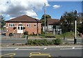
The Village Hall, High Street, Graveley
Built in 1926, according to the village website.
Image: © Humphrey Bolton
Taken: 18 Sep 2012
0.01 miles
3
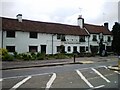
The Waggon and Horses at Graveley
A traditional public house in the centre of Graveley. There is competition for your custom here with The George and Dragon right next door and a Hungry Horse just up the road.
Image: © Mike W Hallett
Taken: 10 Jun 2009
0.02 miles
4
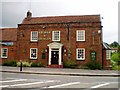
The George and Dragon at Graveley
At one time Graveley was on the Great North Road, so it is not surprising to find somewhere to stop and eat. But you have a choice. Not only do you find the George and Dragon but the Waggon and Horses is right next door and there is a Hungry Horse just up the road.
Image: © Mike W Hallett
Taken: 10 Jun 2009
0.03 miles
5
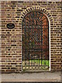
The Grange
Gateway to the house beyond.
Image: © Dennis simpson
Taken: 12 Nov 2010
0.04 miles
8
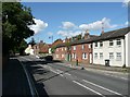
High Street, Graveley
The grid reference is for the two pairs of 19C houses, between which is a passage to the rear. They are listed ‘for group value’, Grade II. High Street is the old Great North Road.
Image: © Humphrey Bolton
Taken: 18 Sep 2012
0.06 miles
9
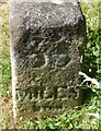
Old Milestone by High Street, the B197, Graveley parish
Carved stone post by the B197 (was A1), in parish of GRAVELEY (NORTH HERTFORDSHIRE District), High Street, opposite 'The Milehouse', on grass verge at South end of village, on East side of road. Stevenage stone, erected by the Stevenage & Biggleswade turnpike trust in the 19th century.
Inscription reads:-
: 33 / MILES / FROM / LONDON : : 33 / MILES / FROM / LONDON :
Grade II listed.
List Entry Number: 1102531
https://historicengland.org.uk/listing/the-list/list-entry/1102531
Milestone Society National ID: HE_LY33.
Image: © MW Hallett
Taken: 16 Aug 2002
0.07 miles
10
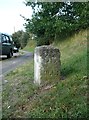
South face of milestone, High Street, Graveley
This is a Grade II listed structure. The listing details state that it was made in the 18C, probably of Portland Stone, for the Stevenage and Biggleswade Turnpike Trust (founded 1720), and that the inscription on the north face is '33 / MILES / from / LONDON'. Also that the similar inscription much weathered on the south face suggests that the stone reversed when the inscription required recutting. (Branch Johnson (1970)187). The 1894 1:2500 map gives the other distance as ‘Baldock 4 miles’.
Image: © Humphrey Bolton
Taken: 18 Sep 2012
0.08 miles