IMAGES TAKEN NEAR TO
Great North Road, HITCHIN, SG4 7EH
Introduction
This page details the photographs taken nearby to Great North Road, SG4 7EH by members of the Geograph project.
The Geograph project started in 2005 with the aim of publishing, organising and preserving representative images for every square kilometre of Great Britain, Ireland and the Isle of Man.

There are currently over 7.5m images from over14,400 individuals and you can help contribute to the project by visiting https://www.geograph.org.uk
Image Map
Images are licensed for reuse under creativecommons.org/licenses/by-sa/2.0
Notes
- Clicking on the map will re-center to the selected point.
- The higher the marker number, the further away the image location is from the centre of the postcode.
Image Listing (6 Images Found)
Images are licensed for reuse under creativecommons.org/licenses/by-sa/2.0
Image
Details
Distance
2
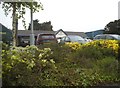
Star of a bridleway at the B197, near Graveley
This ramp of broken stone makes it easy to climb up what was probably a muddy or overgrown slope. The large bird table on the left is a puzzle.
Image: © Humphrey Bolton
Taken: 5 Feb 2020
0.08 miles
3
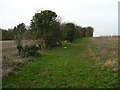
Bridleway, Willian
This is a nice grassy track and does not appear to be used much. It leads to the diversion shown in Image
Image: © Humphrey Bolton
Taken: 5 Feb 2020
0.10 miles
4
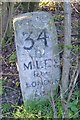
Old Milestone by the B197, south of Jack's Hill, Letchworth parish
Carved stone post by the B197 (was A1), in parish of LETCHWORTH (NORTH HERTFORDSHIRE District), South of Jack's Hill, in roadside undergrowth, on West side of road. Stevenage stone, erected by the Stevenage & Biggleswade turnpike trust in the 19th century.
Inscription reads:-
34
MILES
from
LONDON
Rivet and carved benchmark on top.
Grade II listed.
List Entry Number: 1175063 https://historicengland.org.uk/listing/the-list/list-entry/1175063
Milestone Society National ID: HE_LY34.
Image: © MW Hallett
Taken: 16 Aug 2002
0.13 miles
5
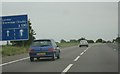
Steady going on the A1(M)
Approaching junction 8, heading south.
Image: © Mr Ignavy
Taken: 5 Jun 2011
0.20 miles
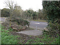
6
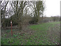
Diverted bridleway, Willian
This is where the bridleway has been severed by the A1(M). The diversion is not shown on the county council's rights of way map, but is indicated by a waymark, and presumably goes to the subway under the motorway further north.
Image: © Humphrey Bolton
Taken: 5 Feb 2020
0.22 miles