IMAGES TAKEN NEAR TO
Halls Green, HITCHIN, SG4 7DZ
Introduction
This page details the photographs taken nearby to Halls Green, SG4 7DZ by members of the Geograph project.
The Geograph project started in 2005 with the aim of publishing, organising and preserving representative images for every square kilometre of Great Britain, Ireland and the Isle of Man.

There are currently over 7.5m images from over14,400 individuals and you can help contribute to the project by visiting https://www.geograph.org.uk
Image Map (Loading...)


Getting Data...Please wait
Leaflet Map data © OpenStreetMap
Images are licensed for reuse under creativecommons.org/licenses/by-sa/2.0
Notes
- Clicking on the map will re-center to the selected point.
- The higher the marker number, the further away the image location is from the centre of the postcode.
Image Listing (7 Images Found)
Images are licensed for reuse under creativecommons.org/licenses/by-sa/2.0
Image
Details
Distance
7
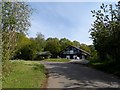
Large modern house near Hall's Green
This house incorporates a lot of glass into its structure. It replaced an older house on this spot. The previous house is visible on Google Street View date stamped 2013.
Image: © Bikeboy
Taken: 10 May 2015
0.25 miles