IMAGES TAKEN NEAR TO
London Road, KNEBWORTH, SG3 6HB
Introduction
This page details the photographs taken nearby to London Road, SG3 6HB by members of the Geograph project.
The Geograph project started in 2005 with the aim of publishing, organising and preserving representative images for every square kilometre of Great Britain, Ireland and the Isle of Man.

There are currently over 7.5m images from over14,400 individuals and you can help contribute to the project by visiting https://www.geograph.org.uk
Image Map
Images are licensed for reuse under creativecommons.org/licenses/by-sa/2.0
Notes
- Clicking on the map will re-center to the selected point.
- The higher the marker number, the further away the image location is from the centre of the postcode.
Image Listing (62 Images Found)
Images are licensed for reuse under creativecommons.org/licenses/by-sa/2.0
Image
Details
Distance
2
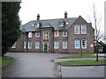
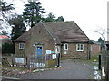
Knebworth: Former St Albans Boys' Home
Completed in 1914 in the neo-Georgian style favoured for institutional buildings at the time and largely unchanged since, the former Boys' Home is in London Road. It is locally listed by virtue of its relevance to the social history of Knebworth, and some original architectural detail such as its symmetry, narrow sash windows and the main entrance with its hipped roof and projecting brick quoins. It is interesting to consider that such a large dedicated building would have been deemed necessary as late as 1914. It is currently in use as the Stepping Stone Pre-School nursery.
Image: © Nigel Cox
Taken: 29 Nov 2009
0.05 miles
3
Knebworth: Haygarth
Haygarth is a development of about 70 maisonettes and flats built around 1970 in the grounds of two large former Victorian houses known as Pelham Lodge and Warwick Lodge on London Road. Access to the upper residential properties is unusually via an open metal staircase, some of which are visible in the photo.
Image: © Nigel Cox
Taken: 29 Nov 2009
0.07 miles
4
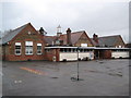
Knebworth Primary & Nursery School
Take away the flat-roofed extensions at the front and the remaining three gable-ended buildings represent the basic fabric of the school as it was opened in 1912. The central section has an attractive bell tower. The school was built primarily to serve the large increase in population in "new" Knebworth following the opening of the railway station built to serve "old" Knebworth in 1884.
The photo was taken at the end of a wet November Sunday afternoon that was just about to get an awful lot wetter...
The School's website is here http://www.knebworth.herts.sch.uk/
Image: © Nigel Cox
Taken: 29 Nov 2009
0.08 miles
5
Knebworth telephone exchange
With a modern extension on the back.
Image: © Robin Hall
Taken: 29 Dec 2005
0.08 miles
6
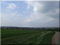
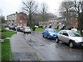
Knebworth from Swangleys Lane
Knebworth. It's where I'm from. I think I've always imagined that heaven probably looks a little bit like this. Not to say I like it, but it has an air of timeless peace about it. Nothing ever changes in Knebworth.
Image: © Matthew Luckins
Taken: 13 Apr 2009
0.09 miles
7
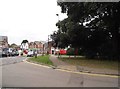
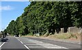
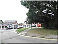
Swangley's Lane at the junction of London Road
Image: © David Howard
Taken: 7 Sep 2017
0.09 miles
8
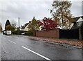
Swangley's Lane at the junction of London Road
Image: © David Howard
Taken: 7 Sep 2017
0.09 miles
9
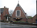
Knebworth: St Thomas More Catholic Church
Located on London Road construction of the church started in 1962. It has a particularly steep pitched roof with the dormer windows visible in the photograph lighting the nave. The engraved glass in the eastern gable end features an image of St Thomas More (1478-1535) himself, while the top of the gable houses the church bell. Internally the church floor slopes down towards the altar enabling good visibility for the whole congregation.
Image: © Nigel Cox
Taken: 29 Nov 2009
0.10 miles