IMAGES TAKEN NEAR TO
Milk Churn Way, KNEBWORTH, SG3 6FJ
Introduction
This page details the photographs taken nearby to Milk Churn Way, SG3 6FJ by members of the Geograph project.
The Geograph project started in 2005 with the aim of publishing, organising and preserving representative images for every square kilometre of Great Britain, Ireland and the Isle of Man.

There are currently over 7.5m images from over14,400 individuals and you can help contribute to the project by visiting https://www.geograph.org.uk
Image Map
Images are licensed for reuse under creativecommons.org/licenses/by-sa/2.0
Notes
- Clicking on the map will re-center to the selected point.
- The higher the marker number, the further away the image location is from the centre of the postcode.
Image Listing (21 Images Found)
Images are licensed for reuse under creativecommons.org/licenses/by-sa/2.0
Image
Details
Distance
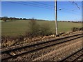
1
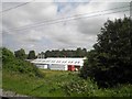
Industrial unit alongside the East Coast main railway
Image: © Steve Fareham
Taken: 10 Jul 2013
0.03 miles
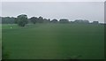
5
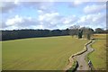
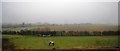
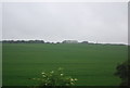
View from a Peterborough-London train - Fields near Woolmer Green
Image: © Nigel Thompson
Taken: 7 Feb 2017
0.11 miles
6
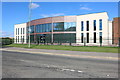
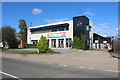
Lessiter's chocolates, Woolmer Green
They have been hand making chocolates since 1911 and now have this new building complete with a restaurant.
Image: © David Howard
Taken: 6 Sep 2020
0.11 miles
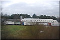
8
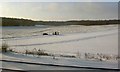
Snowy scene near Woolmer Green
A car has skidded off the minor road. The photograph was taken from a stationary train.
Image: © Steve Fareham
Taken: 18 Dec 2009
0.12 miles