IMAGES TAKEN NEAR TO
Woodstock, KNEBWORTH, SG3 6EA
Introduction
This page details the photographs taken nearby to Woodstock, SG3 6EA by members of the Geograph project.
The Geograph project started in 2005 with the aim of publishing, organising and preserving representative images for every square kilometre of Great Britain, Ireland and the Isle of Man.

There are currently over 7.5m images from over14,400 individuals and you can help contribute to the project by visiting https://www.geograph.org.uk
Image Map
Images are licensed for reuse under creativecommons.org/licenses/by-sa/2.0
Notes
- Clicking on the map will re-center to the selected point.
- The higher the marker number, the further away the image location is from the centre of the postcode.
Image Listing (19 Images Found)
Images are licensed for reuse under creativecommons.org/licenses/by-sa/2.0
Image
Details
Distance
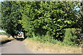
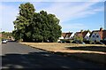
1
Knebworth - estate on the edge.
Until I saw this view of Knebworth I wasn't really aware that it sits in a bit of a hollow.
Image: © Robin Hall
Taken: 29 Dec 2005
0.03 miles
2
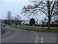
Stockens Green, Knebworth.
Stockens Green is private and owned by Knebworth Tenants Ltd. The sign in the middle of the picture warns people er... not to use the green for er... well pretty much anything really. I got the impression that having fun if you are a child certainly gets frowned on.
Image: © Robin Hall
Taken: 29 Dec 2005
0.15 miles
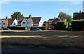
5
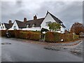
Houses on Stockens Green, Knebworth
These are the same designs used in Hampstead Garden Suburb and related estates. https://www.geograph.org.uk/photo/6816021
Image: © David Howard
Taken: 14 Nov 2021
0.17 miles
6
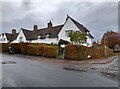
Houses on Stockens Green, Knebworth
These are some of the few houses based on the garden suburb design not in an actual garden suburb.
Image: © David Howard
Taken: 14 Nov 2021
0.18 miles
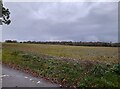
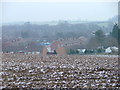
8
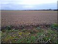
Field by Wych Elm Lane, Woolmer Green
According to the map Wych End Lane is where you cross from Knebworth into Woolmer Green. It's not always easy to distinguish local boundaries.
Image: © David Howard
Taken: 14 Nov 2021
0.22 miles