IMAGES TAKEN NEAR TO
Hydean Way, STEVENAGE, SG2 9XJ
Introduction
This page details the photographs taken nearby to Hydean Way, SG2 9XJ by members of the Geograph project.
The Geograph project started in 2005 with the aim of publishing, organising and preserving representative images for every square kilometre of Great Britain, Ireland and the Isle of Man.

There are currently over 7.5m images from over14,400 individuals and you can help contribute to the project by visiting https://www.geograph.org.uk
Image Map
Images are licensed for reuse under creativecommons.org/licenses/by-sa/2.0
Notes
- Clicking on the map will re-center to the selected point.
- The higher the marker number, the further away the image location is from the centre of the postcode.
Image Listing (7 Images Found)
Images are licensed for reuse under creativecommons.org/licenses/by-sa/2.0
Image
Details
Distance
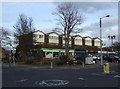
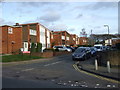
2
Grace Community Church.
I'm not sure what one of these is and it is not quite where the OS say it is. It's round the corner.
Image: © Robin Hall
Taken: 17 Jan 2005
0.07 miles
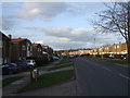
3
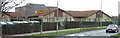
Peartree Spring Infants and Junior Schools.
Just up the road from the Grace Community Church on busy Hydean Way.
Image: © Robin Hall
Taken: 17 Jan 2006
0.07 miles
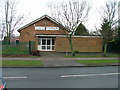
7
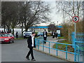
Heathcote School
It is clear to me that the problem with photographing schools is that if done during the daytime you run the risk of attracting attention that you don't want. By night it is too dark. And you can't get close enough really most of the time.
Image: © Robin Hall
Taken: 17 Jan 2005
0.20 miles