IMAGES TAKEN NEAR TO
Watercress Close, STEVENAGE, SG2 9TN
Introduction
This page details the photographs taken nearby to Watercress Close, SG2 9TN by members of the Geograph project.
The Geograph project started in 2005 with the aim of publishing, organising and preserving representative images for every square kilometre of Great Britain, Ireland and the Isle of Man.

There are currently over 7.5m images from over14,400 individuals and you can help contribute to the project by visiting https://www.geograph.org.uk
Image Map
Images are licensed for reuse under creativecommons.org/licenses/by-sa/2.0
Notes
- Clicking on the map will re-center to the selected point.
- The higher the marker number, the further away the image location is from the centre of the postcode.
Image Listing (8 Images Found)
Images are licensed for reuse under creativecommons.org/licenses/by-sa/2.0
Image
Details
Distance
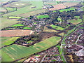
2
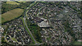
Stevenage from the air
Sainsbury's on Magpie Crescent is prominent.
Image: © Thomas Nugent
Taken: 17 Apr 2024
0.15 miles
3
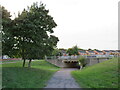
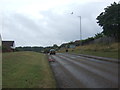
Cycle path, Stevenage
A cycle path in the town of Stevenage.
Image: © Malc McDonald
Taken: 25 Sep 2022
0.17 miles
5
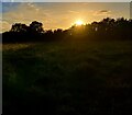
Aston End Sunset
Located along a footpath near Gresley Way on the border of Aston End and Stevenage.
Image: © Andy Steele
Taken: 24 Oct 2023
0.18 miles
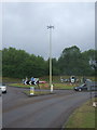
6
Chells Park, Stevenage
Farmland and housing on the eastern edge of Stevenage. Looking south.
Image: © M J Richardson
Taken: 12 Dec 2014
0.18 miles