IMAGES TAKEN NEAR TO
Shephall Way, STEVENAGE, SG2 9RW
Introduction
This page details the photographs taken nearby to Shephall Way, SG2 9RW by members of the Geograph project.
The Geograph project started in 2005 with the aim of publishing, organising and preserving representative images for every square kilometre of Great Britain, Ireland and the Isle of Man.

There are currently over 7.5m images from over14,400 individuals and you can help contribute to the project by visiting https://www.geograph.org.uk
Image Map
Images are licensed for reuse under creativecommons.org/licenses/by-sa/2.0
Notes
- Clicking on the map will re-center to the selected point.
- The higher the marker number, the further away the image location is from the centre of the postcode.
Image Listing (8 Images Found)
Images are licensed for reuse under creativecommons.org/licenses/by-sa/2.0
Image
Details
Distance
1
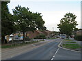
Shephall Way, Stevenage
Shephall Way is a residential road in Stevenage. Traffic calming measures have been installed, including speed cushions in the foreground and a chicane a short distance further along. These indicate that this is a busier road through the residential district of Shephall.
Image: © Malc McDonald
Taken: 25 Sep 2022
0.03 miles
2
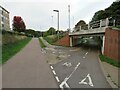
Cycle path junction, Stevenage
A junction of cycle paths in Stevenage, with pedestrian paths alongside. The tunnel enables pedestrians and cyclists to pass beneath a busy road.
Image: © Malc McDonald
Taken: 25 Sep 2022
0.06 miles
4
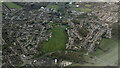
Stevenage from the air
Peartree Park is prominent.
Image: © Thomas Nugent
Taken: 17 Apr 2024
0.13 miles
5
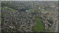
Stevenage from the air
Lots of green space in this part of the town, Peartree Park being the most prominent.
Image: © Thomas Nugent
Taken: 17 Apr 2024
0.14 miles
6
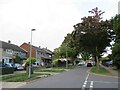
Burwell Road, Stevenage
Burwell Road is a residential road in Stevenage.
Image: © Malc McDonald
Taken: 25 Sep 2022
0.18 miles
7
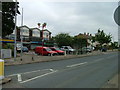
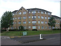
Hydean Way Shops
Typical of local shops in Stevenage new town. Above a parade of shops including a small supermarket, take away food outlet and Post Office there are maisonettes accessed from the rear. To the right there are 2/3 bedroomed homes.
Image: © Robin Hall
Taken: 21 Jul 2005
0.23 miles
8
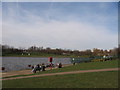
Fairlands Valley Park
this is of the south east bank of the largest lake, taken from near the car park and cafe
Image: © Jo Hennessey
Taken: 11 Mar 2007
0.23 miles