IMAGES TAKEN NEAR TO
Burwell Road, STEVENAGE, SG2 9RH
Introduction
This page details the photographs taken nearby to Burwell Road, SG2 9RH by members of the Geograph project.
The Geograph project started in 2005 with the aim of publishing, organising and preserving representative images for every square kilometre of Great Britain, Ireland and the Isle of Man.

There are currently over 7.5m images from over14,400 individuals and you can help contribute to the project by visiting https://www.geograph.org.uk
Image Map
Images are licensed for reuse under creativecommons.org/licenses/by-sa/2.0
Notes
- Clicking on the map will re-center to the selected point.
- The higher the marker number, the further away the image location is from the centre of the postcode.
Image Listing (3 Images Found)
Images are licensed for reuse under creativecommons.org/licenses/by-sa/2.0
Image
Details
Distance
1
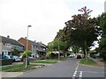
Burwell Road, Stevenage
Burwell Road is a residential road in Stevenage.
Image: © Malc McDonald
Taken: 25 Sep 2022
0.07 miles
2
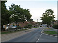
Shephall Way, Stevenage
Shephall Way is a residential road in Stevenage. Traffic calming measures have been installed, including speed cushions in the foreground and a chicane a short distance further along. These indicate that this is a busier road through the residential district of Shephall.
Image: © Malc McDonald
Taken: 25 Sep 2022
0.19 miles
3
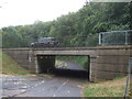
Underpass beneath Six Hills Way, Stevenage
Used by a cycle path.
Image: © JThomas
Taken: 27 Jul 2019
0.21 miles