IMAGES TAKEN NEAR TO
Sparrow Drive, STEVENAGE, SG2 9FD
Introduction
This page details the photographs taken nearby to Sparrow Drive, SG2 9FD by members of the Geograph project.
The Geograph project started in 2005 with the aim of publishing, organising and preserving representative images for every square kilometre of Great Britain, Ireland and the Isle of Man.

There are currently over 7.5m images from over14,400 individuals and you can help contribute to the project by visiting https://www.geograph.org.uk
Image Map
Images are licensed for reuse under creativecommons.org/licenses/by-sa/2.0
Notes
- Clicking on the map will re-center to the selected point.
- The higher the marker number, the further away the image location is from the centre of the postcode.
Image Listing (7 Images Found)
Images are licensed for reuse under creativecommons.org/licenses/by-sa/2.0
Image
Details
Distance
1
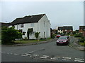
Parishes Mead.
Parishes mead is a newer development on the east side of Stevenage. There is a mixture of private and social housing here.
Image: © Robin Hall
Taken: 25 Jul 2005
0.09 miles
2
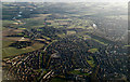
Stevenage from the air
The Poplars area in the south east of Stevenage. The swollen River Beane can be seen to the top left, beyond Aston.
Image: © Thomas Nugent
Taken: 7 Feb 2014
0.09 miles
3
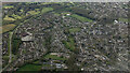
Stevenage from the air
Looking over the Poplars area of the town.
Image: © Thomas Nugent
Taken: 17 Apr 2024
0.09 miles
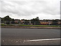
4
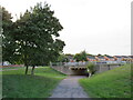
Cycle path, Stevenage
A cycle path in the town of Stevenage.
Image: © Malc McDonald
Taken: 25 Sep 2022
0.14 miles
5
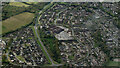
Stevenage from the air
Sainsbury's on Magpie Crescent is prominent.
Image: © Thomas Nugent
Taken: 17 Apr 2024
0.16 miles
7
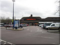
Sainsbury's, Magpie Crescent, Stevenage
Image: © Alex McGregor
Taken: 10 Jan 2011
0.22 miles