IMAGES TAKEN NEAR TO
Hertford Road, STEVENAGE, SG2 8RS
Introduction
This page details the photographs taken nearby to Hertford Road, SG2 8RS by members of the Geograph project.
The Geograph project started in 2005 with the aim of publishing, organising and preserving representative images for every square kilometre of Great Britain, Ireland and the Isle of Man.

There are currently over 7.5m images from over14,400 individuals and you can help contribute to the project by visiting https://www.geograph.org.uk
Image Map
Images are licensed for reuse under creativecommons.org/licenses/by-sa/2.0
Notes
- Clicking on the map will re-center to the selected point.
- The higher the marker number, the further away the image location is from the centre of the postcode.
Image Listing (14 Images Found)
Images are licensed for reuse under creativecommons.org/licenses/by-sa/2.0
Image
Details
Distance
1
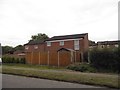
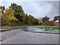
Rear of houses from Hertford Road
The fronts are on Skipton Close
Image: © David Howard
Taken: 7 Sep 2017
0.06 miles
3
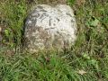
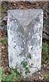
Old Milestone by Hertford Road, Broadwater, Stevenage parish
Carved stone post by the UC road, in parish of STEVENAGE (STEVENAGE District), Hertford Road, Broadwater, on the verge, on North side of road, next to waste bin and footpath. Watton stone, erected by the Watton turnpike trust in the 19th century.
Inscription reads:-
: 30 :
(To London)
Carved benchmark and pivot on top.
Milestone Society National ID: HE_X30.
Image: © MW Hallett
Taken: 26 Apr 2003
0.10 miles
4
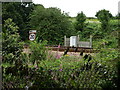
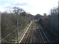
Railway Line
Railway line close to housing estate in Steveange.
Image: © Dennis simpson
Taken: 17 Jul 2011
0.17 miles
5
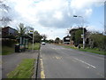
Berkeley Close at the junction of Hertford Road
Image: © David Howard
Taken: 14 Nov 2021
0.18 miles
6
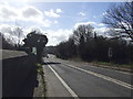
Railway heading south east
Towards Hertford.
Image: © JThomas
Taken: 22 Feb 2014
0.18 miles
7
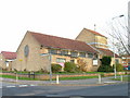
Church of St Peter, Broadwater.
One of a series of three photos taken from within a couple of hundred yards of each other. Church shops and flats. A whole community?
Image: © Robin Hall
Taken: 29 Nov 2005
0.19 miles
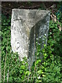
9
Old Milestone by the B197, Stevenage Road, Knebworth
Concrete post by the B197 (was A1), in parish of Knebworth (North Hertfordshire District), half mile South of "Roebuck" PH, in roadside ditch, on West side of road. Erected by the Welwyn turnpike trust in the 20th century.
Inscription reads:-
: STEVENAGE / 2 : : LONDON / 29 :
Milestone Society National ID: HE_LY29
Image: © MW Hallett
Taken: 16 Aug 2002
0.23 miles
10
Old Milestone
Old milestone near to Old Knebworth, Hertfordshire for overall view see
Image: © Keith Evans
Taken: 16 May 2013
0.23 miles