IMAGES TAKEN NEAR TO
Broad Oak Way, STEVENAGE, SG2 8RD
Introduction
This page details the photographs taken nearby to Broad Oak Way, SG2 8RD by members of the Geograph project.
The Geograph project started in 2005 with the aim of publishing, organising and preserving representative images for every square kilometre of Great Britain, Ireland and the Isle of Man.

There are currently over 7.5m images from over14,400 individuals and you can help contribute to the project by visiting https://www.geograph.org.uk
Image Map
Images are licensed for reuse under creativecommons.org/licenses/by-sa/2.0
Notes
- Clicking on the map will re-center to the selected point.
- The higher the marker number, the further away the image location is from the centre of the postcode.
Image Listing (15 Images Found)
Images are licensed for reuse under creativecommons.org/licenses/by-sa/2.0
Image
Details
Distance
1
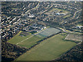
Fairlands Valley Park, Stevenage
An open park and woodland area with sports facilities. The school in the centre is The Valley School, a secondary school for pupils with autism, speech and language communication needs and learning difficulties.http://www.thevalley.herts.sch.uk/aboutus/index.html
Image: © M J Richardson
Taken: 12 Dec 2014
0.07 miles
2
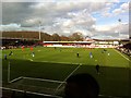
The Lamex Stadium, Stevenage
Players, coaching staff and groundmen on the pitch prior to the Football League 1 fixture between Stevenage FC and Peterborough United which Peterborough won 1-0. The result kept Peterborough in 6th place and Stevenage remained 24th and bottom of the league.
Built in 1980 it is also known as Broadhall Way. A small stadium by Football League standards with a capacity of only 6,722 reflecting the fact that Stevenage did not become a league club until the 2010/2011 season. See http://en.wikipedia.org/wiki/Stevenage_Borough
Beyond the end of the ground there is a big top of a travelling circus.
Image: © Peter Garner
Taken: 22 Feb 2014
0.13 miles
3
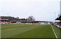
Broadhall Way, Stevenage Borough Football Club
Image: © nick macneill
Taken: 11 Jan 2002
0.13 miles
4
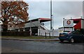
Stevenage Borough FC
Taken from the club's car park across the Hertford Road.
Image: © Robin Hall
Taken: 21 Jul 2005
0.16 miles
5
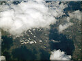
The Valley School from the air
Some of the sports fields appear to be flooded.
Image: © Thomas Nugent
Taken: 7 Feb 2014
0.16 miles
6
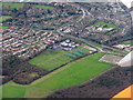
Stevenage from the air
Lamex Stadium, home of Stevenage FC, can be seen near the centre of the photo. Viewed from a Birmingham bound flight from Prague.
Image: © Thomas Nugent
Taken: 11 Feb 2022
0.16 miles
8

Our Mutual friend pub
On Broadwater Crescent.
Image: © JThomas
Taken: 22 Feb 2014
0.18 miles
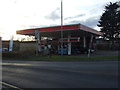
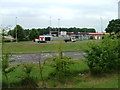
10
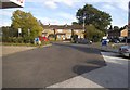
Esso petrol station on Broadwater Crescent, Stevenage
Image: © David Howard
Taken: 28 Sep 2017
0.19 miles