IMAGES TAKEN NEAR TO
Burydale, STEVENAGE, SG2 8AT
Introduction
This page details the photographs taken nearby to Burydale, SG2 8AT by members of the Geograph project.
The Geograph project started in 2005 with the aim of publishing, organising and preserving representative images for every square kilometre of Great Britain, Ireland and the Isle of Man.

There are currently over 7.5m images from over14,400 individuals and you can help contribute to the project by visiting https://www.geograph.org.uk
Image Map
Images are licensed for reuse under creativecommons.org/licenses/by-sa/2.0
Notes
- Clicking on the map will re-center to the selected point.
- The higher the marker number, the further away the image location is from the centre of the postcode.
Image Listing (14 Images Found)
Images are licensed for reuse under creativecommons.org/licenses/by-sa/2.0
Image
Details
Distance
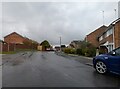
1
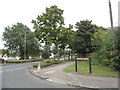
Brook Drive at the junction of Broadwater Crescent
Image: © David Howard
Taken: 7 Sep 2017
0.11 miles
2
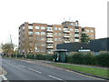
Flats on Broadwater Avenue
Most housing in this area consists of two storey houses but there are a number of blocks of flats like this.
Image: © Robin Hall
Taken: 29 Nov 2005
0.13 miles
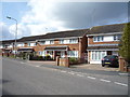
3
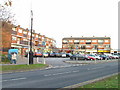
Broadwater Avenue shops
Very busy local shops in the same style as several other Stevenage neighbourhood centres.
Image: © Robin Hall
Taken: 29 Nov 2005
0.15 miles
4
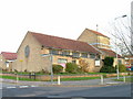
Church of St Peter, Broadwater.
One of a series of three photos taken from within a couple of hundred yards of each other. Church shops and flats. A whole community?
Image: © Robin Hall
Taken: 29 Nov 2005
0.19 miles
7
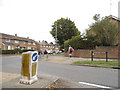
Ashdown Road at the junction of Broadwater Crescent
Image: © David Howard
Taken: 7 Sep 2017
0.21 miles
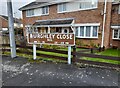
10
Burghley Close at the junction of Hertford Road
Image: © David Howard
Taken: 14 Nov 2021
0.23 miles