IMAGES TAKEN NEAR TO
Luffenhall, STEVENAGE, SG2 7PX
Introduction
This page details the photographs taken nearby to SG2 7PX by members of the Geograph project.
The Geograph project started in 2005 with the aim of publishing, organising and preserving representative images for every square kilometre of Great Britain, Ireland and the Isle of Man.

There are currently over 7.5m images from over14,400 individuals and you can help contribute to the project by visiting https://www.geograph.org.uk
Image Map
Images are licensed for reuse under creativecommons.org/licenses/by-sa/2.0
Notes
- Clicking on the map will re-center to the selected point.
- The higher the marker number, the further away the image location is from the centre of the postcode.
Image Listing (12 Images Found)
Images are licensed for reuse under creativecommons.org/licenses/by-sa/2.0
Image
Details
Distance
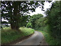
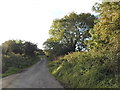
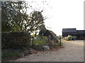
3
The road to Harveyshill Farm from Luffenhall
Image: © Jeff Tomlinson
Taken: 11 Apr 2007
0.08 miles
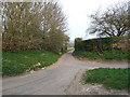
7
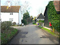
Buildings in Luffenhall
On the left the Old Ram and Hurdle, a 17C former inn. On the right a 16C corn barn at Manor farm. Both buildings are listed, Grade II.
Image: © Humphrey Bolton
Taken: 1 Feb 2022
0.19 miles
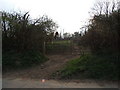
9
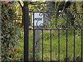
Anode sign in Luffenhall
It's the first I've seen of these and presume it's part of an electrical earth
Image: © David Howard
Taken: 5 Oct 2017
0.20 miles