IMAGES TAKEN NEAR TO
Clay End, STEVENAGE, SG2 7JE
Introduction
This page details the photographs taken nearby to Clay End, SG2 7JE by members of the Geograph project.
The Geograph project started in 2005 with the aim of publishing, organising and preserving representative images for every square kilometre of Great Britain, Ireland and the Isle of Man.

There are currently over 7.5m images from over14,400 individuals and you can help contribute to the project by visiting https://www.geograph.org.uk
Image Map
Images are licensed for reuse under creativecommons.org/licenses/by-sa/2.0
Notes
- Clicking on the map will re-center to the selected point.
- The higher the marker number, the further away the image location is from the centre of the postcode.
Image Listing (4 Images Found)
Images are licensed for reuse under creativecommons.org/licenses/by-sa/2.0
Image
Details
Distance
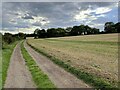
2
Farmland looking towards Holmes Farm
Image: © Philip Jeffrey
Taken: 18 Sep 2022
0.18 miles
3
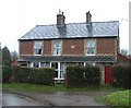
Cottages at Clay End
Clay end is not very big. This is about half of it.
Image: © Robin Hall
Taken: 3 Jan 2006
0.21 miles