IMAGES TAKEN NEAR TO
Aston Lane, STEVENAGE, SG2 7EL
Introduction
This page details the photographs taken nearby to Aston Lane, SG2 7EL by members of the Geograph project.
The Geograph project started in 2005 with the aim of publishing, organising and preserving representative images for every square kilometre of Great Britain, Ireland and the Isle of Man.

There are currently over 7.5m images from over14,400 individuals and you can help contribute to the project by visiting https://www.geograph.org.uk
Image Map
Images are licensed for reuse under creativecommons.org/licenses/by-sa/2.0
Notes
- Clicking on the map will re-center to the selected point.
- The higher the marker number, the further away the image location is from the centre of the postcode.
Image Listing (12 Images Found)
Images are licensed for reuse under creativecommons.org/licenses/by-sa/2.0
Image
Details
Distance
1
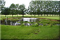
Small pond
Small pond on the Stevenage Golf Course 18th fairway, about 100 yards from the green.
Image: © Barry Ephgrave
Taken: 17 Jul 2011
0.13 miles
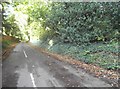
3

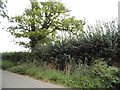
Tree on the corner of Dene Lane, Aston
Image: © David Howard
Taken: 28 Sep 2017
0.19 miles
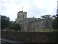
5
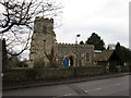
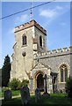
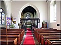
St Mary's Church, Aston
The church is built of flint with stone dressings on the nave and chancel and the roofs are covered with copper.
Image: © John Sanderson
Taken: 4 Jan 2006
0.22 miles
7
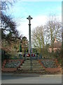
Aston war memorial.
Next door to the church.
Image: © Robin Hall
Taken: 10 Feb 2006
0.24 miles