IMAGES TAKEN NEAR TO
High Elms Lane, STEVENAGE, SG2 7DG
Introduction
This page details the photographs taken nearby to High Elms Lane, SG2 7DG by members of the Geograph project.
The Geograph project started in 2005 with the aim of publishing, organising and preserving representative images for every square kilometre of Great Britain, Ireland and the Isle of Man.

There are currently over 7.5m images from over14,400 individuals and you can help contribute to the project by visiting https://www.geograph.org.uk
Image Map
Images are licensed for reuse under creativecommons.org/licenses/by-sa/2.0
Notes
- Clicking on the map will re-center to the selected point.
- The higher the marker number, the further away the image location is from the centre of the postcode.
Image Listing (8 Images Found)
Images are licensed for reuse under creativecommons.org/licenses/by-sa/2.0
Image
Details
Distance
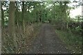
1
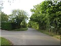
Road junction near Stevenage
A minor road junction in north Hertfordshire countryside.
Image: © Malc McDonald
Taken: 25 Sep 2022
0.07 miles
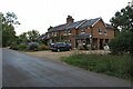
5
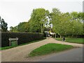
Cutting Hill Farm, near Stevenage
Cutting Hill Farm in the north Hertfordshire countryside. The green sign indicates that the farm is now used as a doctor's surgery.
Image: © Malc McDonald
Taken: 25 Sep 2022
0.19 miles
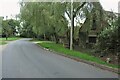
6
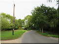
Whempstead Road, near Stevenage
Whempstead Road is a minor road through the countryside in north Hertfordshire.
Image: © Malc McDonald
Taken: 25 Sep 2022
0.19 miles
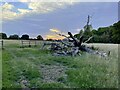
8
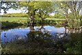
Pond near Burn's Green
Taken from the footpath from High Elms Lane to Burn's Green.
Image: © David Kemp
Taken: 4 May 2024
0.24 miles