IMAGES TAKEN NEAR TO
Burns Green, STEVENAGE, SG2 7DB
Introduction
This page details the photographs taken nearby to Burns Green, SG2 7DB by members of the Geograph project.
The Geograph project started in 2005 with the aim of publishing, organising and preserving representative images for every square kilometre of Great Britain, Ireland and the Isle of Man.

There are currently over 7.5m images from over14,400 individuals and you can help contribute to the project by visiting https://www.geograph.org.uk
Image Map
Images are licensed for reuse under creativecommons.org/licenses/by-sa/2.0
Notes
- Clicking on the map will re-center to the selected point.
- The higher the marker number, the further away the image location is from the centre of the postcode.
Image Listing (4 Images Found)
Images are licensed for reuse under creativecommons.org/licenses/by-sa/2.0
Image
Details
Distance
1
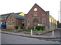
Benington Methodist Church
Built in 1862 and rebuilt in 1933, the church is on Whempstead Road in Burn's Green.
Image: © Nigel Cox
Taken: 18 May 2006
0.22 miles
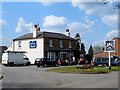
3
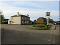
Lordship Arms, Benington, near Stevenage
The Lordship Arms pub in the village of Benington, in north Hertfordshire.
Image: © Malc McDonald
Taken: 25 Sep 2022
0.25 miles
4
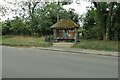
Bus stop book shelves
Community library at Burn's Green
Image: © Philip Jeffrey
Taken: 25 Sep 2022
0.25 miles