IMAGES TAKEN NEAR TO
Gardners End, STEVENAGE, SG2 7AR
Introduction
This page details the photographs taken nearby to Gardners End, SG2 7AR by members of the Geograph project.
The Geograph project started in 2005 with the aim of publishing, organising and preserving representative images for every square kilometre of Great Britain, Ireland and the Isle of Man.

There are currently over 7.5m images from over14,400 individuals and you can help contribute to the project by visiting https://www.geograph.org.uk
Image Map
Images are licensed for reuse under creativecommons.org/licenses/by-sa/2.0
Notes
- Clicking on the map will re-center to the selected point.
- The higher the marker number, the further away the image location is from the centre of the postcode.
Image Listing (5 Images Found)
Images are licensed for reuse under creativecommons.org/licenses/by-sa/2.0
Image
Details
Distance
1
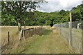
Back Lane, Cottered/Ardeley
Back Lane, a former roman road, marks the boundary between Ardeley (left) and Cottered (right). Drinkwater Wood is on the right.
Image: © David Kemp
Taken: 4 Nov 2022
0.10 miles
2
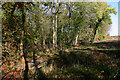
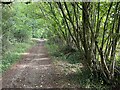
Drinkwater Wood, Cottered
The footpath leads from Back Lane to Cottered Warren and here runs parallel to the right of Drinkwater Wood.
Image: © David Kemp
Taken: 4 Nov 2022
0.12 miles