IMAGES TAKEN NEAR TO
Crab Apple Way, SANDY, SG19 3LS
Introduction
This page details the photographs taken nearby to Crab Apple Way, SG19 3LS by members of the Geograph project.
The Geograph project started in 2005 with the aim of publishing, organising and preserving representative images for every square kilometre of Great Britain, Ireland and the Isle of Man.

There are currently over 7.5m images from over14,400 individuals and you can help contribute to the project by visiting https://www.geograph.org.uk
Image Map
Images are licensed for reuse under creativecommons.org/licenses/by-sa/2.0
Notes
- Clicking on the map will re-center to the selected point.
- The higher the marker number, the further away the image location is from the centre of the postcode.
Image Listing (18 Images Found)
Images are licensed for reuse under creativecommons.org/licenses/by-sa/2.0
Image
Details
Distance
1
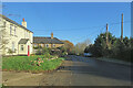
Gamlingay Heath: a stinkpipe on Heath Road
Looking towards Gamlingay from the corner of the lane to Dennis Green, where - on the right of the picture - a concrete-cased sewer vent pipe of a type familiar in Cambridgeshire rises out of the hedgerow.
Image: © John Sutton
Taken: 8 Dec 2022
0.14 miles
2
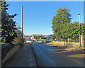
Gamlingay: a stinkpipe on Green End
The sewer vent pipe on the left is the concrete-cased type found in a number of Cambridgeshire villages. In the middle distance in the centre of the picture is a former Methodist Chapel, built in the 1850s, which now houses a pre-school.
Image: © John Sutton
Taken: 8 Dec 2022
0.16 miles
3
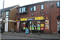
Gamlingay Convenience Store
It's actually a grocer's. There are no conveniences on sale, not even behind the counter.
Image: © David Howard
Taken: 22 Aug 2019
0.22 miles
4
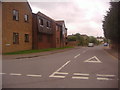
Green End from the junction of Waresley Road
Image: © David Howard
Taken: 31 May 2012
0.22 miles
5

Old Milepost
Old milepost on the B1040 at Gamlingay, Cambridgeshire. For close up view see http://www.geograph.org.uk/photo/5525245
Image: © Keith Evans
Taken: 29 Jun 2017
0.23 miles
6
Jannah Indian restaurant, Gamlingay
Looks like this building used to be a pub.
Image: © Bikeboy
Taken: 26 May 2013
0.23 miles
7

To St. Ives 14
Old milepost on the B1040 at Gamlingay, Cambridgeshire. For overall view see http://www.geograph.org.uk/photo/5525242.
Image: © Keith Evans
Taken: 29 Jun 2017
0.23 miles
8

Ghost Sign
Ghost sign on building at Gamlingay, Cambridgeshire, For view of other sign see http://www.geograph.org.uk/photo/5525270 and overall view see http://www.geograph.org.uk/photo/5525293
Image: © Keith Evans
Taken: 29 Jun 2017
0.24 miles
9

Old Building With Ghost Signs
Old building with ghost signs at Gamlingay, Cambridgeshire for close up views of the signs see http://www.geograph.org.uk/photo/5525258 http://www.geograph.org.uk/photo/5525270
Image: © Keith Evans
Taken: 29 Jun 2017
0.24 miles
10

Ghost Sign
Ghost sign on building at Gamlingay, Cambridgeshire, For view of other sign see http://www.geograph.org.uk/photo/5525258 and overall view see http://www.geograph.org.uk/photo/5525293
Image: © Keith Evans
Taken: 29 Jun 2017
0.24 miles