IMAGES TAKEN NEAR TO
Mill Lane, SANDY, SG19 2PG
Introduction
This page details the photographs taken nearby to Mill Lane, SG19 2PG by members of the Geograph project.
The Geograph project started in 2005 with the aim of publishing, organising and preserving representative images for every square kilometre of Great Britain, Ireland and the Isle of Man.

There are currently over 7.5m images from over14,400 individuals and you can help contribute to the project by visiting https://www.geograph.org.uk
Image Map
Images are licensed for reuse under creativecommons.org/licenses/by-sa/2.0
Notes
- Clicking on the map will re-center to the selected point.
- The higher the marker number, the further away the image location is from the centre of the postcode.
Image Listing (11 Images Found)
Images are licensed for reuse under creativecommons.org/licenses/by-sa/2.0
Image
Details
Distance
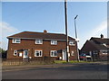
2
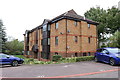
House building on the edge of Potton
Image: © Philip Jeffrey
Taken: 10 Oct 2021
0.12 miles
3

Marty The Potton Lower School Owl
Marty was made from the card models made by students at a series of workshops during an art week in the school.
He is made from mild and stainless steel. We called him Marty because one of his feet looks like the letter 'M'.
http://www.culturechallenge.co.uk/providers/paul-pibworth/
http://www.paulpibworth.co.uk
Image: © Paul Pibworth
Taken: 9 Dec 2012
0.14 miles
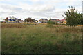
5
Potton Station
Opened June 1862, close January 1968. See http://www.disused-stations.org.uk/p/potton/index.shtml for the history of the station and associated railway line, photos etc.
Image: © d brewerton
Taken: Unknown
0.21 miles
7
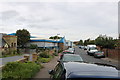
Varsity Line
The Varsity Line connected Oxford and Cambridge and train services ran on the section between Bedford and Cambridge until the end of 1967 https://en.wikipedia.org/wiki/Varsity_Line . Plans are underway to reopen the line in stages between Oxford and Cambridge, and the route is now known as East West Rail.
Some local authorities have taken steps to protect disused rail routes. Hence much of the original alignment between Oxford and Bedford will be/is being reused as it was because it was not built over in the meantime. However, there are several places between Bedford and Cambridge where the old route has been built over, and consequently a completely fresh route is likely to be constructed for this section.
This is one of three blocks of flats that have recently been built on the former alignment of the Varsity Line by Willow Road, Potton. They are not far from the business premises in Shannon Place, also built over the Varsity Line. Yet there are other places in this village where the corridor of the old line remains intact.
More details of future plans for East West Rail are available from https://www.eastwestrail.org.uk/central-section-overview/
Image: © Andrew Bodman
Taken: 10 Sep 2018
0.22 miles
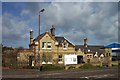
8
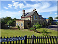
Former station building, Potton
Now a house, it is grade II listed, from 1862. This was the second Potton station, the original station was a terminus at the end of a different alignment finishing west of Biggleswade Road, where the current houses 22-28 are. A building survives here behind the houses, variously described as an engine shed or goods shed.
Shannon Place is named after the name of the first locomotive on the Sandy and Potton Railway. It is unlikely to have run to this station, but would have run to the first station. It later ran on the Wantage Tramway and has survived, currently at Didcot Railway Centre, but not a runner.
Image: © Robin Webster
Taken: 14 May 2017
0.24 miles
9
Varsity Line
The Varsity Line connected Oxford and Cambridge and train services ran on the section between Bedford and Cambridge until the end of 1967 https://en.wikipedia.org/wiki/Varsity_Line . Plans are underway to reopen the line in stages between Oxford and Cambridge, and the route is now known as East West Rail.
Some local authorities have taken steps to protect disused rail routes. Hence much of the original alignment between Oxford and Bedford will be/is being reused as it was because it was not built over in the meantime. However, there are several places between Bedford and Cambridge where the old route has been built over, and consequently a completely fresh route is likely to be constructed for this section.
Part of the (second) Potton Station can be seen in the foreground on the left, this now being used as a house. The road straight ahead is Shannon Place. The business premises on the left are built on the alignment of the Varsity Line, which was situated on the far side of the station and ran parallel to Shannon Place. Additional history of the railway and stations in this village may be found from other Geograph contributors and from http://www.disused-stations.org.uk/p/potton/index.shtml
More details of future plans for East West Rail are available from https://www.eastwestrail.org.uk/central-section-overview/
Image: © Andrew Bodman
Taken: 10 Sep 2018
0.25 miles
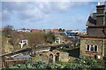
10

Potton: the former railway station
The Bedford-Cambridge line opened in 1861 and closed on 1 January 1968. The station building at Potton is now a private house, but the platforms and the canopy with delicate cast-iron columns and spandrels remain. Sandy and Potton were the only stations on the Oxford-Cambridge Varsity Line which had platform canopies. The ruined brick base of the water tower is in the foreground on the left. The rest of the station site is occupied by an industrial estate.
Image: © John Sutton
Taken: 7 Jan 2018
0.25 miles