IMAGES TAKEN NEAR TO
Stratford Road, SANDY, SG19 2AB
Introduction
This page details the photographs taken nearby to Stratford Road, SG19 2AB by members of the Geograph project.
The Geograph project started in 2005 with the aim of publishing, organising and preserving representative images for every square kilometre of Great Britain, Ireland and the Isle of Man.

There are currently over 7.5m images from over14,400 individuals and you can help contribute to the project by visiting https://www.geograph.org.uk
Image Map
Images are licensed for reuse under creativecommons.org/licenses/by-sa/2.0
Notes
- Clicking on the map will re-center to the selected point.
- The higher the marker number, the further away the image location is from the centre of the postcode.
Image Listing (19 Images Found)
Images are licensed for reuse under creativecommons.org/licenses/by-sa/2.0
Image
Details
Distance
1
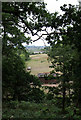
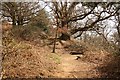
View From The Quarry Footpath
Looking through a gap in the trees on The Lodge Nature Reserve towards Stratford and Beeston.
Image: © Martin Addison
Taken: 2 Jun 2011
0.09 miles
2
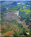
Sandy from the air
The A1 is to the left, the East Coast Main Line railway is to the right, with Sandy in between. The X shape of the former RAF Tempsford can be seen towards the top right.
Click on this http://en.wikipedia.org/wiki/RAF_Tempsford to go to the wikipedia article about RAF Tempsford.
Image: © Thomas Nugent
Taken: 9 May 2011
0.11 miles
3
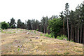
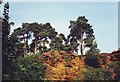
Galley Hill Iron Age Fort
Located in the southwestern corner of The Lodge RSPB Reserve, the earth banks of the Hillfort are well preserved. The fort is broadly rectangular in shape. It would have given a good view to the south and west over the Ivel valley.
Image: © Martin Addison
Taken: 2 Jun 2011
0.11 miles

6
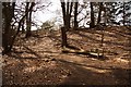
Sandy Lodge Promontory Fort
Path ascending to the earth ramparts of Sandy Lodge Promontory Fort https://historicengland.org.uk/listing/the-list/list-entry/1015006 at The Lodge. An early Iron Age fort excavated in 1969.
Image: © Richard Croft
Taken: 14 Apr 2013
0.16 miles

9
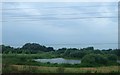
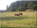
Sandy Warren, RSPB headquarters and Nature Reaserve
There are basically two walks around the RSPB reserve, one through gentle heathland, the other, more undulating through forest. On the latter, one passes these rocks which reminded me more of Surrey than Bedfordshire.
Image: © nick macneill
Taken: 16 Sep 2003
0.20 miles
10
Sandy Lodge Promontory Fort
Path ascending to the earth ramparts of Sandy Lodge Promontory Fort https://historicengland.org.uk/listing/the-list/list-entry/1015006 at The Lodge. An early Iron Age fort excavated in 1969.
Image: © Richard Croft
Taken: 14 Apr 2013
0.20 miles