IMAGES TAKEN NEAR TO
Sunderland Road, SANDY, SG19 1JU
Introduction
This page details the photographs taken nearby to Sunderland Road, SG19 1JU by members of the Geograph project.
The Geograph project started in 2005 with the aim of publishing, organising and preserving representative images for every square kilometre of Great Britain, Ireland and the Isle of Man.

There are currently over 7.5m images from over14,400 individuals and you can help contribute to the project by visiting https://www.geograph.org.uk
Image Map
Images are licensed for reuse under creativecommons.org/licenses/by-sa/2.0
Notes
- Clicking on the map will re-center to the selected point.
- The higher the marker number, the further away the image location is from the centre of the postcode.
Image Listing (58 Images Found)
Images are licensed for reuse under creativecommons.org/licenses/by-sa/2.0
Image
Details
Distance
1
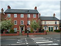
New houses, High Street, Sandy
The pair on the right are dated 2007 and I thought the brickwork of the big house on the left looked new. Sure enough, the satellite view shows an empty site.
Image: © Humphrey Bolton
Taken: 5 May 2017
0.04 miles
2
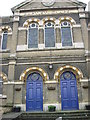
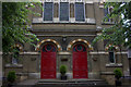
This is the baptist church
This picture was taken on a geography field trip discovering land use with St Swithun's V.C. Lower School.
This picture was taken near Sandy roundabout. It is a very old building.
The land use is mostly business but this is a religious building
Image: © St Swithun's VC Lower School
Taken: 15 Mar 2007
0.06 miles
3
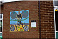
Frederick Thomas Bidlake memorial mosaic
This is on the Sandy library. Bidlake was a 19th century racing cyclist who became an administrator for bicycle racing until his death in the 1930's
Image: © Robert Eva
Taken: 8 Jun 2018
0.06 miles
4
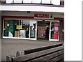
Spar
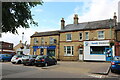
This is the Spar which is near the roundabout in Sandy Town Centre.
This picture was taken on a geography field trip with St Swithun's V.C. Lower School. We discovered land use in our local area.
This area is mainly business land use.
Image: © St Swithun's VC Lower School
Taken: 15 Mar 2007
0.06 miles
5
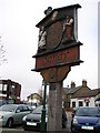
The Sandy Sign (from the other side)
This is a picture of the sign in Sandy (taken from the other side, by a different pupil)
This picture was taken on a geography field trip discovering land use with St Swithun's V.C. Lower School.
The land use is business here.
Image: © St Swithun's VC Lower School
Taken: 15 Mar 2007
0.07 miles
8
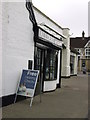
Allders opticians
Allders the opticians is on the market square.
This picture was taken on a geography field trip discovering land use with St Swithun's V.C. Lower School.
The land use around this area is mostly business and some housing.
Image: © St Swithun's VC Lower School
Taken: 15 Mar 2007
0.08 miles
9
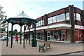
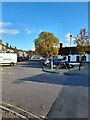
Market Square, Sandy
Looking towards the High Street
Image: © David Howard
Taken: 29 Aug 2021
0.08 miles